IMAGES TAKEN NEAR TO
Fairhead Road, BALLYCASTLE, BT54 6RD
Introduction
This page details the photographs taken nearby to Fairhead Road, BT54 6RD by members of the Geograph project.
The Geograph project started in 2005 with the aim of publishing, organising and preserving representative images for every square kilometre of Great Britain, Ireland and the Isle of Man.

There are currently over 7.5m images from over14,400 individuals and you can help contribute to the project by visiting https://www.geograph.org.uk
Image Map
Images are licensed for reuse under creativecommons.org/licenses/by-sa/2.0
Notes
- Clicking on the map will re-center to the selected point.
- The higher the marker number, the further away the image location is from the centre of the postcode.
Image Listing (4 Images Found)
Images are licensed for reuse under creativecommons.org/licenses/by-sa/2.0
Image
Details
Distance
1
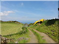
Disused coal mine
Track to a disused coal mine labelled on the OSNI map.
Image: © Mat Tuck
Taken: 31 May 2014
0.13 miles
2
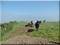
Fair Head, cattle grazing
Off Fairhead Road.
Image: © Mike Faherty
Taken: 29 Jun 2018
0.17 miles
3
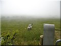
Ballyvoy, sheep grazing
Off Fairhead Road. Sea mist has not yet burnt away.
Image: © Mike Faherty
Taken: 29 Jun 2018
0.25 miles
4
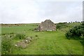
Ruin, Lisnacalliagh
Once a home, a farmstead with outbuildings.
Image: © Bob Embleton
Taken: 21 Aug 2006
0.25 miles