IMAGES TAKEN NEAR TO
Torr Road, BALLYCASTLE, BT54 6RB
Introduction
This page details the photographs taken nearby to Torr Road, BT54 6RB by members of the Geograph project.
The Geograph project started in 2005 with the aim of publishing, organising and preserving representative images for every square kilometre of Great Britain, Ireland and the Isle of Man.

There are currently over 7.5m images from over14,400 individuals and you can help contribute to the project by visiting https://www.geograph.org.uk
Image Map
Images are licensed for reuse under creativecommons.org/licenses/by-sa/2.0
Notes
- Clicking on the map will re-center to the selected point.
- The higher the marker number, the further away the image location is from the centre of the postcode.
Image Listing (4 Images Found)
Images are licensed for reuse under creativecommons.org/licenses/by-sa/2.0
Image
Details
Distance
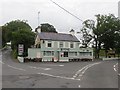

3
The junction of Torr Road and an unnamed cul-de-sac at Ballyvoy Cross Roads
The small village of Ballyvoy is clustered around the cross roads.
Image: © Eric Jones
Taken: 26 Sep 2013
0.20 miles
4
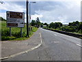
Cushendall Road, Ballyvoy
Heading east
Image: © Kenneth Allen
Taken: 5 Jul 2014
0.22 miles