IMAGES TAKEN NEAR TO
Mary Street, BALLYCASTLE, BT54 6QH
Introduction
This page details the photographs taken nearby to Mary Street, BT54 6QH by members of the Geograph project.
The Geograph project started in 2005 with the aim of publishing, organising and preserving representative images for every square kilometre of Great Britain, Ireland and the Isle of Man.

There are currently over 7.5m images from over14,400 individuals and you can help contribute to the project by visiting https://www.geograph.org.uk
Image Map
Images are licensed for reuse under creativecommons.org/licenses/by-sa/2.0
Notes
- Clicking on the map will re-center to the selected point.
- The higher the marker number, the further away the image location is from the centre of the postcode.
Image Listing (167 Images Found)
Images are licensed for reuse under creativecommons.org/licenses/by-sa/2.0
Image
Details
Distance
1
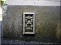
Flush Bracket, Ballycastle
Flush bracket located on the north-western tip of the (New) Primary School on Quay Road, Ballycastle.
The number on the bracket is OSBM 3449.
The mark is 6.08 metres above MSL.
A flush bracket is a type of bench mark set onto the face of a building. See also http://www.geograph.org.uk/search.php?i=11037856 for many other examples I have found.
Image: © Rossographer
Taken: 19 Jun 2010
0.04 miles
2
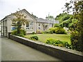
Ballycastle, primary school
Ballycastle Integrated Primary School, on Quay Road. http://www.ballycastleintegrated.com/
Image: © Mike Faherty
Taken: 26 Jun 2018
0.05 miles
3
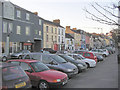
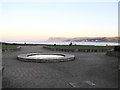
Ballycastle Promenade area.
The lower part of the town facing the sea.
Image: © Kenneth Allen
Taken: 29 Jan 2006
0.08 miles
4
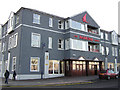
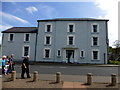
The Marine Hotel, Ballycastle
It is at the seafront
Image: © Kenneth Allen
Taken: 29 Jan 2006
0.08 miles
5
Ballycastle sea front
The view is looking towards Fair Head
Image: © Kenneth Allen
Taken: 29 Jan 2006
0.08 miles
6
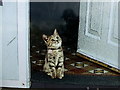
Cat at the front door, Ballycastle
Pictured here Image]
Image: © Kenneth Allen
Taken: 23 May 2015
0.08 miles
7
Period building along Quay Road, Ballycastle
An impressive building which initially had me fooled.
It was derelict with a virtual front - my attention was drawn to Image]
Image: © Kenneth Allen
Taken: 23 May 2015
0.08 miles
8
Ballycastle's War Memorial
This monument commemorates Ballycastle men who fell on the field of war in British and Commonwealth armies. The names of the fallen of the Great War are given on the following link.
http://www.ulsterwarmemorials.net/html/ballycastle.html
Image: © Eric Jones
Taken: 24 Sep 2013
0.09 miles
9
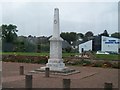
Ballycastle War Memorial
Ballycastle War Memorial, which takes the form of a marble obelisk with a spire seven feet high on which is worked a wreath, is located at the lower end of Quay Road in a square opposite the Manor House and adjacent to the sea front.
On the cap is the inscription:
“To the glory of God and in memory of the brave men who gave their lives for freedom and justice.”
A list of the names recorded on the memorial can be found at War Memorials Online https://www.warmemorialsonline.org.uk/memorial/147218 or Ulster War Memorials http://www.ulsterwarmemorials.net/html/ballycastle.html .
Image: © David Dixon
Taken: 28 Sep 2017
0.09 miles
10

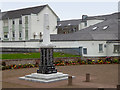
Ballycastle, war memorial
On Quay Road. The middle of the obelisk records those fallen in WWI, and the base WWII.
Image: © Mike Faherty
Taken: 26 Jun 2018
0.09 miles