IMAGES TAKEN NEAR TO
Glenview Road, BALLYCASTLE, BT54 6QE
Introduction
This page details the photographs taken nearby to Glenview Road, BT54 6QE by members of the Geograph project.
The Geograph project started in 2005 with the aim of publishing, organising and preserving representative images for every square kilometre of Great Britain, Ireland and the Isle of Man.

There are currently over 7.5m images from over14,400 individuals and you can help contribute to the project by visiting https://www.geograph.org.uk
Image Map
Images are licensed for reuse under creativecommons.org/licenses/by-sa/2.0
Notes
- Clicking on the map will re-center to the selected point.
- The higher the marker number, the further away the image location is from the centre of the postcode.
Image Listing (4 Images Found)
Images are licensed for reuse under creativecommons.org/licenses/by-sa/2.0
Image
Details
Distance
1

Plaque, Glen Sheask National School
It is located here Image]
Image: © Kenneth Allen
Taken: 29 Jun 2010
0.14 miles
2

Glen Sheask National School
Built in 1834; it has been converted to a holiday home
See close-up of plaque here Image]
Image: © Kenneth Allen
Taken: 29 Jun 2010
0.16 miles
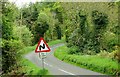
3
The Greenan Road near Ballycastle
The Greenan Road is a minor road running of the Glenshesk Road Image The view is just after it has left the main road.
Image: © Albert Bridge
Taken: 10 May 2008
0.20 miles
4
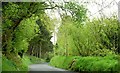
The Glenshesk Road near Ballycastle (3)
See Image Most of the road is reasonably well aligned. This section makes a few twists and turns (albeit scenic ones) as it approaches the Glenshesk Bridge over the Glenshesk River. The view is towards Armoy.
Image: © Albert Bridge
Taken: 10 May 2008
0.23 miles