IMAGES TAKEN NEAR TO
Cushendall Road, BALLYCASTLE, BT54 6PS
Introduction
This page details the photographs taken nearby to Cushendall Road, BT54 6PS by members of the Geograph project.
The Geograph project started in 2005 with the aim of publishing, organising and preserving representative images for every square kilometre of Great Britain, Ireland and the Isle of Man.

There are currently over 7.5m images from over14,400 individuals and you can help contribute to the project by visiting https://www.geograph.org.uk
Image Map
Images are licensed for reuse under creativecommons.org/licenses/by-sa/2.0
Notes
- Clicking on the map will re-center to the selected point.
- The higher the marker number, the further away the image location is from the centre of the postcode.
Image Listing (7 Images Found)
Images are licensed for reuse under creativecommons.org/licenses/by-sa/2.0
Image
Details
Distance
1
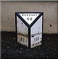
Milepost near Ballycastle
Old milepost located on the main road between Ballycastle and Cushendall. The post records that Belfast is 62 miles away, Ballycastle is 3⅛ miles away and Cushendall is 12¾ miles away.
Image: © Rossographer
Taken: 18 Jun 2011
0.02 miles
2
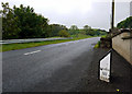
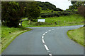
The Cushendall Road near Ballycastle
The main A2 Cushendall Road between Ballycastle and Cushendall. Note the old milepost in the foreground - Image
Image: © Rossographer
Taken: 18 Jun 2011
0.02 miles
3
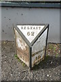
Old Milepost by the A2, Cushendall Road, Drumnakeel
Cast iron milepost on the A2, in the townland of Drumnakeel; Cushendall Road, Ballyvoy, next to wall of No 119. Erected by the county, C19.
Inscription reads:- : BALyCASTLE / 3 ⅛ / (MILES) : : CUSHENDALL / 12¾ / MILES : : BELFAST / 62 :
Milestone Society National ID: ANT_BFBC62.
Image: © Milestone Society
Taken: 23 Jun 2018
0.02 miles
4
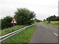
Cushendall Road
The long, and easy climb over the moorland plateau between Ballycastle and Cushendall.
Image: © Richard Webb
Taken: 5 Aug 2013
0.08 miles
6
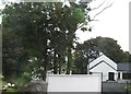
Newly built house on the Cushendall Road
Image: © Eric Jones
Taken: 26 Sep 2013
0.10 miles
7
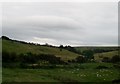
The Carey Valley above the Ballyvoy Bridge
Farming in this area is predominantly pastoral. Sheep and cattle rearing is the mainstay of the farming economy.
Image: © Eric Jones
Taken: 26 Sep 2013
0.10 miles