IMAGES TAKEN NEAR TO
Ballinlea Road, BALLYCASTLE, BT54 6JL
Introduction
This page details the photographs taken nearby to Ballinlea Road, BT54 6JL by members of the Geograph project.
The Geograph project started in 2005 with the aim of publishing, organising and preserving representative images for every square kilometre of Great Britain, Ireland and the Isle of Man.

There are currently over 7.5m images from over14,400 individuals and you can help contribute to the project by visiting https://www.geograph.org.uk
Image Map
Images are licensed for reuse under creativecommons.org/licenses/by-sa/2.0
Notes
- Clicking on the map will re-center to the selected point.
- The higher the marker number, the further away the image location is from the centre of the postcode.
Image Listing (2 Images Found)
Images are licensed for reuse under creativecommons.org/licenses/by-sa/2.0
Image
Details
Distance
1
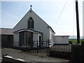
St. Mary's Chapel Ballinlea
The Catholic Church of St. Mary in Ballinlea.
Image: © Willie Duffin
Taken: 19 May 2008
0.18 miles
2
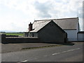
Ballinlea school
This small school beside the Roman Catholic Church is no longer used as a school. The church and local community use it for various social and community functions. The sign on the gable says it is a museum but although it retains some old fitments etc. inside it is not, even in the loosest of terms a museum.
Image: © Willie Duffin
Taken: 19 May 2008
0.19 miles