IMAGES TAKEN NEAR TO
Magheramore Road, BALLYCASTLE, BT54 6JE
Introduction
This page details the photographs taken nearby to Magheramore Road, BT54 6JE by members of the Geograph project.
The Geograph project started in 2005 with the aim of publishing, organising and preserving representative images for every square kilometre of Great Britain, Ireland and the Isle of Man.

There are currently over 7.5m images from over14,400 individuals and you can help contribute to the project by visiting https://www.geograph.org.uk
Image Map
Images are licensed for reuse under creativecommons.org/licenses/by-sa/2.0
Notes
- Clicking on the map will re-center to the selected point.
- The higher the marker number, the further away the image location is from the centre of the postcode.
Image Listing (5 Images Found)
Images are licensed for reuse under creativecommons.org/licenses/by-sa/2.0
Image
Details
Distance
1
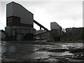
Quarry machinery
Stone grading machinery in Ross's Quarry in the townland of Turraloskin.
Image: © Willie Duffin
Taken: 20 Jun 2008
0.15 miles
2
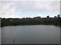
Flooded quarry
These old quarry workings have flooded.Older workings can be seen in the background.
Image: © Willie Duffin
Taken: 20 Jun 2008
0.15 miles
3
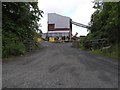
Quarry, Magheramore Road
Looking north
Image: © Kenneth Allen
Taken: 26 Jun 2008
0.17 miles
5
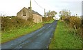
Disused cottage near Ballycastle
A disused cottage, on the Capecastle Road, to the south west of Ballycastle.
Image: © Albert Bridge
Taken: 26 Oct 2008
0.22 miles