IMAGES TAKEN NEAR TO
Islandarragh Road, BALLYCASTLE, BT54 6HS
Introduction
This page details the photographs taken nearby to Islandarragh Road, BT54 6HS by members of the Geograph project.
The Geograph project started in 2005 with the aim of publishing, organising and preserving representative images for every square kilometre of Great Britain, Ireland and the Isle of Man.

There are currently over 7.5m images from over14,400 individuals and you can help contribute to the project by visiting https://www.geograph.org.uk
Image Map
Images are licensed for reuse under creativecommons.org/licenses/by-sa/2.0
Notes
- Clicking on the map will re-center to the selected point.
- The higher the marker number, the further away the image location is from the centre of the postcode.
Image Listing (12 Images Found)
Images are licensed for reuse under creativecommons.org/licenses/by-sa/2.0
Image
Details
Distance
1
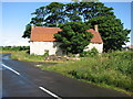
Derelict cottage
Looks as if the tree is growing out the front door.
Image: © Willie Duffin
Taken: 20 Jun 2008
0.02 miles
2
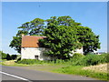
Tin roof building
Tin roof building disused set within trees
Image: © Mat Tuck
Taken: 31 May 2014
0.06 miles
3
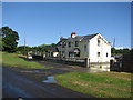
Converted cottage
A nicely converted cottage.
Image: © Willie Duffin
Taken: 20 Jun 2008
0.07 miles
4
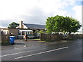
Former school
This is the former Moyarget Primary School. Built in 1968 it was closed in 1995. Purchased by a private owner in 1999 it is now used as his home and the outbuildings are used as part of his business.
Image: © Willie Duffin
Taken: 20 Jun 2008
0.11 miles
5
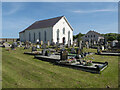
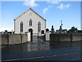
Ramoan Presbyterian Church
Ramoan Presbyterian Church on the Moyarget Road a few miles from Ballycastle.
Image: © Rossographer
Taken: 29 May 2023
0.13 miles
6
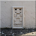
Flush Bracket, Ramoan Presbyterian Church
Flush bracket bench mark on the south-western tip of Ramoan Presbyterian Church Image near Ballycastle.
The number on the bracket is OSBM 3446.
The mark has been levelled to 107.20 metres above MSL.
Image: © Rossographer
Taken: 29 May 2023
0.13 miles
7
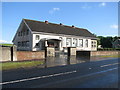
Ramoan Church Hall
Built on the site of the former primary school.
Image: © Willie Duffin
Taken: 20 Jun 2008
0.13 miles
8
Small cottage
A neat little cottage beside Ramoan Presbyterian Church.
Image: © Willie Duffin
Taken: 20 Jun 2008
0.19 miles
9
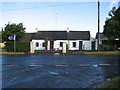
Ramoan Presbyterian Church
This church is known locally as Moyarget church. It's on the B67 opposite the junction with Islandarragh Road.
Image: © Willie Duffin
Taken: 20 Jun 2008
0.21 miles
10
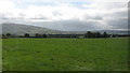
Open countryside
Looking across open country towards Sproule's town.
Image: © Willie Duffin
Taken: 20 Jun 2008
0.24 miles