IMAGES TAKEN NEAR TO
Coleraine Road, BALLYCASTLE, BT54 6EY
Introduction
This page details the photographs taken nearby to Coleraine Road, BT54 6EY by members of the Geograph project.
The Geograph project started in 2005 with the aim of publishing, organising and preserving representative images for every square kilometre of Great Britain, Ireland and the Isle of Man.

There are currently over 7.5m images from over14,400 individuals and you can help contribute to the project by visiting https://www.geograph.org.uk
Image Map
Images are licensed for reuse under creativecommons.org/licenses/by-sa/2.0
Notes
- Clicking on the map will re-center to the selected point.
- The higher the marker number, the further away the image location is from the centre of the postcode.
Image Listing (25 Images Found)
Images are licensed for reuse under creativecommons.org/licenses/by-sa/2.0
Image
Details
Distance
1
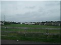
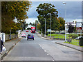
Ballycastle
A mini-roundabout in a residential area in Ballycastle. The ugly red blocks on the skyline are schools, in the next square.
Image: © Anne Burgess
Taken: 6 Jun 2007
0.02 miles
2
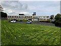
Dalriada Hospital, Ballycastle
It is located along Coleraine Road and occupies the site of the former workhouse
Image: © Kenneth Allen
Taken: 28 Apr 2022
0.10 miles
3
Ballycastle Orange Hall
This hall looks very run-down and dilapidated but I understand this is because it comes under regular attack from vandals etc.and its better left in this condition until needed.
Image: © Willie Duffin
Taken: 20 Jun 2008
0.13 miles
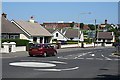
4
Ballycastle, Coleraine Road
Ballycastle (from Irish: Baile an Chaistil, meaning "town of the castle") is a small town in County Antrim. It is located on the north-easternmost coastal tip of the island of Ireland at the northern mainland limit of the Antrim Coast and Glens Area of Outstanding Natural Beauty.
Image: © David Dixon
Taken: 28 Sep 2017
0.13 miles
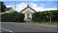
5
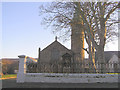
Ballycastle Presbyterian Church
It is located south of the town.
Image: © Kenneth Allen
Taken: 29 Jan 2006
0.13 miles
6
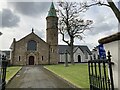
Presbyterian Church, Ballycastle
Pictured along Castle Street
Image: © Kenneth Allen
Taken: 28 Apr 2022
0.16 miles
7
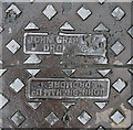
Manhole cover, Ballycastle
Manhole cover located on Castle Street in Ballycastle. It is marked "John Graham Ltd., Dromore". See also Image
Image: © Rossographer
Taken: 18 Jun 2011
0.16 miles
8
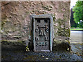
Flush Bracket, Ballycastle
Flush bracket bench mark located on the front wall of Ballycastle Presbyterian Church Image
The number on the bracket is OSBM 3448.
The mark has been levelled to 28.00 metres above MSL.
A flush bracket is a type of bench mark set onto the face of a building. See also http://www.geograph.org.uk/search.php?i=11037856 for many other examples I have found.
Image: © Rossographer
Taken: 18 Jun 2011
0.17 miles
9
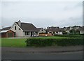
Bungalows in Gortnamaddy Park, Ballycastle
Image: © Eric Jones
Taken: 24 Sep 2013
0.17 miles