IMAGES TAKEN NEAR TO
Leyland Park, BALLYCASTLE, BT54 6DL
Introduction
This page details the photographs taken nearby to Leyland Park, BT54 6DL by members of the Geograph project.
The Geograph project started in 2005 with the aim of publishing, organising and preserving representative images for every square kilometre of Great Britain, Ireland and the Isle of Man.

There are currently over 7.5m images from over14,400 individuals and you can help contribute to the project by visiting https://www.geograph.org.uk
Image Map
Images are licensed for reuse under creativecommons.org/licenses/by-sa/2.0
Notes
- Clicking on the map will re-center to the selected point.
- The higher the marker number, the further away the image location is from the centre of the postcode.
Image Listing (5 Images Found)
Images are licensed for reuse under creativecommons.org/licenses/by-sa/2.0
Image
Details
Distance
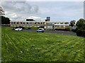
2
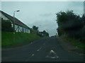
Leyland Farm Road from Leyland Road
The white building is part of an Enterprise Centre.
Image: © Eric Jones
Taken: 24 Sep 2013
0.08 miles
3
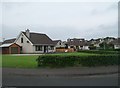
Bungalows in Gortnamaddy Park, Ballycastle
Image: © Eric Jones
Taken: 24 Sep 2013
0.13 miles
4
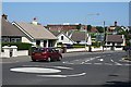
Ballycastle
A mini-roundabout in a residential area in Ballycastle. The ugly red blocks on the skyline are schools, in the next square.
Image: © Anne Burgess
Taken: 6 Jun 2007
0.19 miles
5
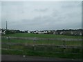
Dalriada Hospital, Ballycastle
It is located along Coleraine Road and occupies the site of the former workhouse
Image: © Kenneth Allen
Taken: 28 Apr 2022
0.24 miles