IMAGES TAKEN NEAR TO
Rathlin Road, BALLYCASTLE, BT54 6AG
Introduction
This page details the photographs taken nearby to Rathlin Road, BT54 6AG by members of the Geograph project.
The Geograph project started in 2005 with the aim of publishing, organising and preserving representative images for every square kilometre of Great Britain, Ireland and the Isle of Man.

There are currently over 7.5m images from over14,400 individuals and you can help contribute to the project by visiting https://www.geograph.org.uk
Image Map
Images are licensed for reuse under creativecommons.org/licenses/by-sa/2.0
Notes
- Clicking on the map will re-center to the selected point.
- The higher the marker number, the further away the image location is from the centre of the postcode.
Image Listing (52 Images Found)
Images are licensed for reuse under creativecommons.org/licenses/by-sa/2.0
Image
Details
Distance
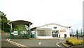
1
Ferry terminal, Ballycastle
The ferry terminal was built to serve the short-lived Campbeltown service. It is now the terminal for the service to Rathlin. The old Rathlin terminal is now the tourist office. So far as I can see the terminal is in this square with its car park in D1241. See also Image
Image: © Albert Bridge
Taken: 7 May 2007
0.13 miles
2
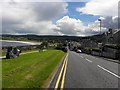
North Street, Ballycastle
Ballycastle (from Irish: Baile an Chaistil, meaning "town of the castle") is a small town in County Antrim. It is located on the north-easternmost coastal tip of the island of Ireland at the northern mainland limit of the Antrim Coast and Glens Area of Outstanding Natural Beauty.
Image: © David Dixon
Taken: 28 Sep 2017
0.15 miles
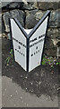
3
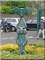
National Cycle Network Milepost, Ballycastle
This sits just outside the Rathlin ferry terminal in Ballycastle (seen in Image).
Image: © Rossographer
Taken: 24 May 2008
0.16 miles
4
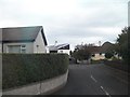
Bungalows at Lir Court, off the Clare Road at Ballycastle
Image: © Eric Jones
Taken: 26 Sep 2013
0.17 miles
5
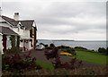
Cliff-top villa overlooking Ballycastle Harbour
Rathlin forms the background.
Image: © Eric Jones
Taken: 26 Sep 2013
0.17 miles
6
Milestone, Ballycastle
North St.
Bushmills / 9 / Miles // Pans Rock / Ballycastle / 1 / Mile
Image: © Kevin Mcgrath
Taken: 16 Jun 2021
0.18 miles
7
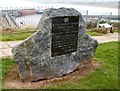
Marconi plaque, Ballycastle
This plaque, overlooking the harbour, commemorates the first commercial radio signal on 6 July 1896. It was sent from Rathlin to Ballycastle.
Image: © Albert Bridge
Taken: 16 Feb 2008
0.18 miles
8
Ferry terminal, Ballycastle (2)
See Image The Calmac signs have now been replaced by those of the new operator. For the record, the enclosure on the left was used for checking tickets and searching vehicles during the days of the ferry to Campbeltown.
Image: © Albert Bridge
Taken: 26 Jul 2008
0.19 miles
9
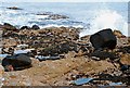
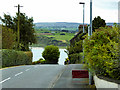
The coast at Ballycastle (5)
See Image Almost the same place but looking seawards. The black rock (right) provides a point of reference. The tide is on the flood.
Image: © Albert Bridge
Taken: 16 Feb 2008
0.20 miles
10
North Street, Ballycastle
My attention was drawn to the plaque on the left Image]
Image: © Kenneth Allen
Taken: 18 Aug 2010
0.20 miles