IMAGES TAKEN NEAR TO
Bregagh Road, BALLYMONEY, BT53 8YW
Introduction
This page details the photographs taken nearby to Bregagh Road, BT53 8YW by members of the Geograph project.
The Geograph project started in 2005 with the aim of publishing, organising and preserving representative images for every square kilometre of Great Britain, Ireland and the Isle of Man.

There are currently over 7.5m images from over14,400 individuals and you can help contribute to the project by visiting https://www.geograph.org.uk
Image Map
Images are licensed for reuse under creativecommons.org/licenses/by-sa/2.0
Notes
- Clicking on the map will re-center to the selected point.
- The higher the marker number, the further away the image location is from the centre of the postcode.
Image Listing (5 Images Found)
Images are licensed for reuse under creativecommons.org/licenses/by-sa/2.0
Image
Details
Distance
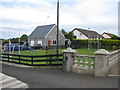
3
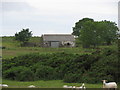
Unused farm building
What appears to be a former cottage now used as an occasional farm building.
Image: © Willie Duffin
Taken: 27 Jun 2008
0.19 miles
4
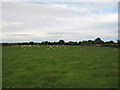
Carrivcashel townland
Looking across Carrivcashel town where the sheep are having a rest.
Image: © Willie Duffin
Taken: 27 Jun 2008
0.22 miles
5
Minor football pitch
A very small Gaelic football pitch in someone's front lawn.
Image: © Willie Duffin
Taken: 27 Jun 2008
0.25 miles