IMAGES TAKEN NEAR TO
Manister Road, BALLYMONEY, BT53 8UA
Introduction
This page details the photographs taken nearby to Manister Road, BT53 8UA by members of the Geograph project.
The Geograph project started in 2005 with the aim of publishing, organising and preserving representative images for every square kilometre of Great Britain, Ireland and the Isle of Man.

There are currently over 7.5m images from over14,400 individuals and you can help contribute to the project by visiting https://www.geograph.org.uk
Image Map
Images are licensed for reuse under creativecommons.org/licenses/by-sa/2.0
Notes
- Clicking on the map will re-center to the selected point.
- The higher the marker number, the further away the image location is from the centre of the postcode.
Image Listing (1 Images Found)
Images are licensed for reuse under creativecommons.org/licenses/by-sa/2.0
Image
Details
Distance
1
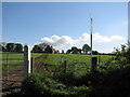
Farmhouse for sale
An old unused farmhouse for sale in the townland of Manister. The track through the field is not the main access to the property, there is a proper laneway further to the right.
Image: © Willie Duffin
Taken: 11 May 2009
0.21 miles