IMAGES TAKEN NEAR TO
Glenshesk Road, BALLYMONEY, BT53 8RJ
Introduction
This page details the photographs taken nearby to Glenshesk Road, BT53 8RJ by members of the Geograph project.
The Geograph project started in 2005 with the aim of publishing, organising and preserving representative images for every square kilometre of Great Britain, Ireland and the Isle of Man.

There are currently over 7.5m images from over14,400 individuals and you can help contribute to the project by visiting https://www.geograph.org.uk
Image Map
Images are licensed for reuse under creativecommons.org/licenses/by-sa/2.0
Notes
- Clicking on the map will re-center to the selected point.
- The higher the marker number, the further away the image location is from the centre of the postcode.
Image Listing (7 Images Found)
Images are licensed for reuse under creativecommons.org/licenses/by-sa/2.0
Image
Details
Distance
1
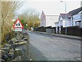
Glenshesk Road, Armoy
Looking ENE with St. Olcan's Primary School on the right.
Image: © Dean Molyneaux
Taken: 27 Feb 2010
0.17 miles
3
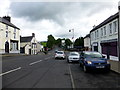
Main Street, Armoy
In the centre of this County Antrim village, on the A44 to Ballycastle.
Image: © Dean Molyneaux
Taken: 27 Feb 2010
0.22 miles
4
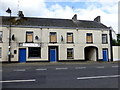
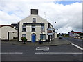
McCafferty's Pub, Armoy
Pictured along Hillside Road
It includes the Victory Bar
Image: © Kenneth Allen
Taken: 4 Aug 2014
0.24 miles
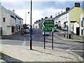
5
Main Street, Armoy
Heading ENE to Drones Road
Image: © Kenneth Allen
Taken: 4 Aug 2014
0.24 miles
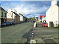
6
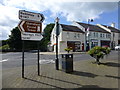
Armoy, County Antrim
Looking south-west at the junction of Hillside Road, Main Street and Drones Road
Image: © Kenneth Allen
Taken: 4 Aug 2014
0.24 miles
7
McCafferty's Pub (side view)
Pictured along Main Street, Armoy
Image: © Kenneth Allen
Taken: 4 Aug 2014
0.24 miles