IMAGES TAKEN NEAR TO
Magheramore Road, BALLYMONEY, BT53 8RE
Introduction
This page details the photographs taken nearby to Magheramore Road, BT53 8RE by members of the Geograph project.
The Geograph project started in 2005 with the aim of publishing, organising and preserving representative images for every square kilometre of Great Britain, Ireland and the Isle of Man.

There are currently over 7.5m images from over14,400 individuals and you can help contribute to the project by visiting https://www.geograph.org.uk
Image Map
Images are licensed for reuse under creativecommons.org/licenses/by-sa/2.0
Notes
- Clicking on the map will re-center to the selected point.
- The higher the marker number, the further away the image location is from the centre of the postcode.
Image Listing (3 Images Found)
Images are licensed for reuse under creativecommons.org/licenses/by-sa/2.0
Image
Details
Distance
1
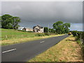
New farmhouse
A large recently constructed farmhouse on the Magheramore road.
Image: © Willie Duffin
Taken: 20 Jun 2008
0.13 miles
2
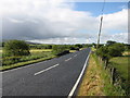
Magheramore road
A view south along the Magheramore road.Taken from the small bridge over the Inver Burn.
Image: © Willie Duffin
Taken: 20 Jun 2008
0.14 miles
3
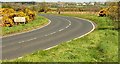
The Magheramore Road near Armoy
The Magheramore Road is part of the main road from the Ballycastle Fork Image (on the Belfast – Coleraine road) to Ballycastle. The view is towards Ballycastle.
Image: © Albert Bridge
Taken: 18 Apr 2009
0.17 miles