IMAGES TAKEN NEAR TO
Carncullagh Road, BALLYMONEY, BT53 8PS
Introduction
This page details the photographs taken nearby to Carncullagh Road, BT53 8PS by members of the Geograph project.
The Geograph project started in 2005 with the aim of publishing, organising and preserving representative images for every square kilometre of Great Britain, Ireland and the Isle of Man.

There are currently over 7.5m images from over14,400 individuals and you can help contribute to the project by visiting https://www.geograph.org.uk
Image Map
Images are licensed for reuse under creativecommons.org/licenses/by-sa/2.0
Notes
- Clicking on the map will re-center to the selected point.
- The higher the marker number, the further away the image location is from the centre of the postcode.
Image Listing (4 Images Found)
Images are licensed for reuse under creativecommons.org/licenses/by-sa/2.0
Image
Details
Distance
1
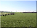
Level fields
The scene just to the north of Stranocum
Image: © Kenneth Allen
Taken: 29 Jan 2006
0.08 miles
2
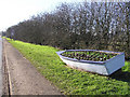
Road to Stranocum
This boat won't be on the high seas any more, but it has floral displays.
Image: © Kenneth Allen
Taken: 29 Jan 2006
0.20 miles
3
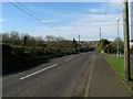
Ballinlea Road, Stranocum
The Ballinlea Road, part of the B147, on the southern edge of the village of Stranocum.
Image: © Rossographer
Taken: 11 Apr 2009
0.20 miles
4
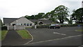
Bushvale Primary School
A primary school just outside Stranocum on the B147 Ballinlea road.
Image: © Willie Duffin
Taken: 28 May 2008
0.22 miles