IMAGES TAKEN NEAR TO
Gracehill Road, BALLYMONEY, BT53 8JA
Introduction
This page details the photographs taken nearby to Gracehill Road, BT53 8JA by members of the Geograph project.
The Geograph project started in 2005 with the aim of publishing, organising and preserving representative images for every square kilometre of Great Britain, Ireland and the Isle of Man.

There are currently over 7.5m images from over14,400 individuals and you can help contribute to the project by visiting https://www.geograph.org.uk
Image Map
Images are licensed for reuse under creativecommons.org/licenses/by-sa/2.0
Notes
- Clicking on the map will re-center to the selected point.
- The higher the marker number, the further away the image location is from the centre of the postcode.
Image Listing (5 Images Found)
Images are licensed for reuse under creativecommons.org/licenses/by-sa/2.0
Image
Details
Distance
1
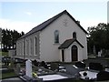
Bushvale Presbyterian Church
Built in 1805. Renovated in 1927.
Image: © Kenneth Allen
Taken: 26 Jun 2008
0.17 miles
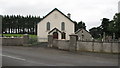
2
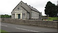
Bushvale Church Hall
It is located beside the Presbyterian Church
Image: © Kenneth Allen
Taken: 26 Jun 2008
0.17 miles
3
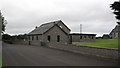
Bushvale Minor church hall
This is a small hall behind the main church. I have placed it in D0228 as it was so close to the grid line.
Image: © Willie Duffin
Taken: 27 Jun 2008
0.17 miles
4
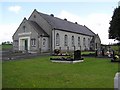
Bushvale Presbyterian Church
Built in 1805 and renovated in 1927 this is a typical Presbyterian church of the era (square and functional).
Image: © Willie Duffin
Taken: 27 Jun 2008
0.19 miles