IMAGES TAKEN NEAR TO
McArthur Avenue, BALLYMONEY, BT53 8BH
Introduction
This page details the photographs taken nearby to McArthur Avenue, BT53 8BH by members of the Geograph project.
The Geograph project started in 2005 with the aim of publishing, organising and preserving representative images for every square kilometre of Great Britain, Ireland and the Isle of Man.

There are currently over 7.5m images from over14,400 individuals and you can help contribute to the project by visiting https://www.geograph.org.uk
Image Map
Images are licensed for reuse under creativecommons.org/licenses/by-sa/2.0
Notes
- Clicking on the map will re-center to the selected point.
- The higher the marker number, the further away the image location is from the centre of the postcode.
Image Listing (5 Images Found)
Images are licensed for reuse under creativecommons.org/licenses/by-sa/2.0
Image
Details
Distance
1
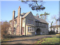
The old manse, Dervock
An impressive building built in 1937, which requires some renovation.
Image: © Kenneth Allen
Taken: 29 Jan 2006
0.15 miles
2
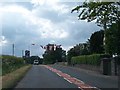
Exiting Dervock on the Knock Road
Knock Road links Dervock and Ballymoney.
Image: © Eric Jones
Taken: 16 Jun 2013
0.17 miles
4
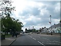
Dervock main Street as seen from a clock tower of the co-op community building
The old co-op building was almost derelict and it was decide with the help of public funding the knock down and completely restore the building to village ownership.the building now contains on the upper floor two three bedroom fully furnished flats with two shop units and a community office on the ground floor
Image: © frank mclernon
Taken: 4 Jul 2000
0.20 miles
5
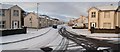
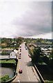
Castlewood Park, Dervock
Looking west towards the entrance of the estate.
Image: © Kenneth Allen
Taken: 2 Feb 2008
0.23 miles