IMAGES TAKEN NEAR TO
Scroggy Road, BALLYMONEY, BT53 7NQ
Introduction
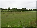
This page details the photographs taken nearby to Scroggy Road, BT53 7NQ by members of the Geograph project.
The Geograph project started in 2005 with the aim of publishing, organising and preserving representative images for every square kilometre of Great Britain, Ireland and the Isle of Man.

There are currently over 7.5m images from over14,400 individuals and you can help contribute to the project by visiting https://www.geograph.org.uk
Image Map
Images are licensed for reuse under creativecommons.org/licenses/by-sa/2.0
Notes
- Clicking on the map will re-center to the selected point.
- The higher the marker number, the further away the image location is from the centre of the postcode.
Image Listing (2 Images Found)
Images are licensed for reuse under creativecommons.org/licenses/by-sa/2.0
Image
Details
Distance
1
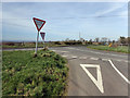
Scroggy Road
Two "Give Way" signs required at this double junction where Scroggy Road joins Moneycannon road which itself immediately joins Bendooragh Road. Tricky enough to negoiate on a dark night if you're unfamiliar with the area. Near Bendooragh.
Image: © Robert Ashby
Taken: 26 Mar 2017
0.11 miles