IMAGES TAKEN NEAR TO
Bann Road, BALLYMONEY, BT53 7NA
Introduction
This page details the photographs taken nearby to Bann Road, BT53 7NA by members of the Geograph project.
The Geograph project started in 2005 with the aim of publishing, organising and preserving representative images for every square kilometre of Great Britain, Ireland and the Isle of Man.

There are currently over 7.5m images from over14,400 individuals and you can help contribute to the project by visiting https://www.geograph.org.uk
Image Map
Images are licensed for reuse under creativecommons.org/licenses/by-sa/2.0
Notes
- Clicking on the map will re-center to the selected point.
- The higher the marker number, the further away the image location is from the centre of the postcode.
Image Listing (5 Images Found)
Images are licensed for reuse under creativecommons.org/licenses/by-sa/2.0
Image
Details
Distance
1
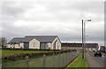
The B66
Drumreagh Presbyterian Church. Near Bendooragh.
Image: © Robert Ashby
Taken: 6 Apr 2017
0.05 miles
2
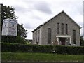
Drumreagh Presbyterian Church
It is located to the south of Bendooragh on Bann Road
Image: © Kenneth Allen
Taken: 16 Jun 2008
0.05 miles
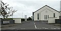
3

Drumreagh Church Hall
It is located beside the church
Image: © Kenneth Allen
Taken: 16 Jun 2008
0.05 miles
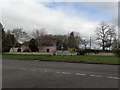
4
Drumreagh Presbyterian Church
Drumreagh Presbyterian Church can trace its beginnings to the 29th July 1834 when it was officially recognised as a congregation.
Image: © Russel Wills
Taken: 19 Sep 2023
0.05 miles
5
Leaving Bendooragh
Signage on the B66. The small blue sign indicates that this is on Route 96 of the National Cycle Network.
Image: © Robert Ashby
Taken: 6 Apr 2017
0.14 miles