IMAGES TAKEN NEAR TO
Intermediate Road, BALLYMONEY, BT53 7AL
Introduction
This page details the photographs taken nearby to Intermediate Road, BT53 7AL by members of the Geograph project.
The Geograph project started in 2005 with the aim of publishing, organising and preserving representative images for every square kilometre of Great Britain, Ireland and the Isle of Man.

There are currently over 7.5m images from over14,400 individuals and you can help contribute to the project by visiting https://www.geograph.org.uk
Image Map
Images are licensed for reuse under creativecommons.org/licenses/by-sa/2.0
Notes
- Clicking on the map will re-center to the selected point.
- The higher the marker number, the further away the image location is from the centre of the postcode.
Image Listing (4 Images Found)
Images are licensed for reuse under creativecommons.org/licenses/by-sa/2.0
Image
Details
Distance
1
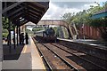
Ballymoney Station
GNRI 85 approaching Ballymoney Station.
The footbridge to the front of the engine, is out of use to passengers due to its unsafe condition. A temporary footbridge has been provided to allow passengers access to the loop platform.
Image: © Wilson Adams
Taken: 20 Jun 2004
0.09 miles
2
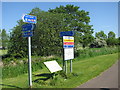
Information signs Ballymoney Riverside Park
A number of signs along the riverside path. I was amused to see the "Do not enter the water" instruction, this was the river where I learned to swim.
Image: © Willie Duffin
Taken: 9 Jun 2013
0.22 miles
3
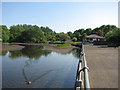
Riverside Park Ballymoney
Leisure facilities along the Ballymoney burn.
Image: © Willie Duffin
Taken: 9 Jun 2013
0.23 miles
4
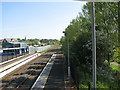
Railway line Ballymoney
Looking North-east towards the B62 road bridge. Taken from the pedestrian walkway.
Image: © Willie Duffin
Taken: 9 Jun 2013
0.23 miles