IMAGES TAKEN NEAR TO
West Field Park, BALLYMONEY, BT53 6QW
Introduction
This page details the photographs taken nearby to West Field Park, BT53 6QW by members of the Geograph project.
The Geograph project started in 2005 with the aim of publishing, organising and preserving representative images for every square kilometre of Great Britain, Ireland and the Isle of Man.

There are currently over 7.5m images from over14,400 individuals and you can help contribute to the project by visiting https://www.geograph.org.uk
Image Map
Images are licensed for reuse under creativecommons.org/licenses/by-sa/2.0
Notes
- Clicking on the map will re-center to the selected point.
- The higher the marker number, the further away the image location is from the centre of the postcode.
Image Listing (4 Images Found)
Images are licensed for reuse under creativecommons.org/licenses/by-sa/2.0
Image
Details
Distance
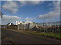
1
Small village at Seacon
View from Seacon High straight down the road to Seacon lower and to the group of houses at Williamson Park.
Image: © Willie Duffin
Taken: 4 Mar 2008
0.05 miles
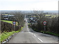
3
Taughey Road
Looking north across the A26 Newbridge Road to Seacon Park.
Image: © Robert Ashby
Taken: 29 Oct 2017
0.12 miles