IMAGES TAKEN NEAR TO
Knock Road, BALLYMONEY, BT53 6NH
Introduction
This page details the photographs taken nearby to Knock Road, BT53 6NH by members of the Geograph project.
The Geograph project started in 2005 with the aim of publishing, organising and preserving representative images for every square kilometre of Great Britain, Ireland and the Isle of Man.

There are currently over 7.5m images from over14,400 individuals and you can help contribute to the project by visiting https://www.geograph.org.uk
Image Map
Images are licensed for reuse under creativecommons.org/licenses/by-sa/2.0
Notes
- Clicking on the map will re-center to the selected point.
- The higher the marker number, the further away the image location is from the centre of the postcode.
Image Listing (5 Images Found)
Images are licensed for reuse under creativecommons.org/licenses/by-sa/2.0
Image
Details
Distance
2
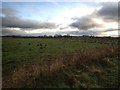
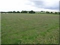
Conagher Road
Rough scrubland looking SE.
Image: © Robert Ashby
Taken: 20 Dec 2017
0.18 miles
5
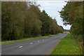
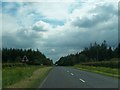
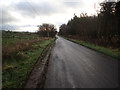
The Knock Road near Ballymoney
The Knock Road runs from Dervock to Ballymoney. The view is towards Dervock with Garry Wood on the left.
Image: © Albert Bridge
Taken: 28 Sep 2007
0.25 miles