IMAGES TAKEN NEAR TO
The Crescent, BALLYMONEY, BT53 6ES
Introduction
This page details the photographs taken nearby to The Crescent, BT53 6ES by members of the Geograph project.
The Geograph project started in 2005 with the aim of publishing, organising and preserving representative images for every square kilometre of Great Britain, Ireland and the Isle of Man.

There are currently over 7.5m images from over14,400 individuals and you can help contribute to the project by visiting https://www.geograph.org.uk
Image Map
Images are licensed for reuse under creativecommons.org/licenses/by-sa/2.0
Notes
- Clicking on the map will re-center to the selected point.
- The higher the marker number, the further away the image location is from the centre of the postcode.
Image Listing (3 Images Found)
Images are licensed for reuse under creativecommons.org/licenses/by-sa/2.0
Image
Details
Distance
1
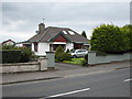
Newal road house (2)
No.48 was my second home on what was then called the Newhill Road. It is opposite the first house and approx.50m to the left.
Image: © Willie Duffin
Taken: 14 May 2009
0.22 miles
2
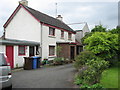
Newal Road house (1)
This was my first home.It was originally two houses and there was no porch and no running water.The roadway was just rough gravel and the lawn on the right was a vegetable garden and an enclosure for my Fathers greyhounds.
Image: © Willie Duffin
Taken: 14 May 2009
0.25 miles
3
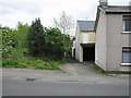
Newal road lane
This short lane leads down to my first home,it seemed much longer when I was a child. What is now shrubbery was another small house similar to that on the right and the two-storey garage wasn't there. It was quite scary coming home late at night as street lighting was almost non-existent.
Image: © Willie Duffin
Taken: 14 May 2009
0.25 miles