IMAGES TAKEN NEAR TO
Margaret Avenue, BALLYMONEY, BT53 6BY
Introduction
This page details the photographs taken nearby to Margaret Avenue, BT53 6BY by members of the Geograph project.
The Geograph project started in 2005 with the aim of publishing, organising and preserving representative images for every square kilometre of Great Britain, Ireland and the Isle of Man.

There are currently over 7.5m images from over14,400 individuals and you can help contribute to the project by visiting https://www.geograph.org.uk
Image Map
Images are licensed for reuse under creativecommons.org/licenses/by-sa/2.0
Notes
- Clicking on the map will re-center to the selected point.
- The higher the marker number, the further away the image location is from the centre of the postcode.
Image Listing (5 Images Found)
Images are licensed for reuse under creativecommons.org/licenses/by-sa/2.0
Image
Details
Distance
1
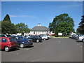
Dalriada Grammar School
The original school building. There are many new buildings to the rear and to the left. The car park was the tennis courts when I was a pupil here, there was not much need for a car park in those days! Just a bike shed.
Image: © Willie Duffin
Taken: 2 Jun 2008
0.10 miles
2
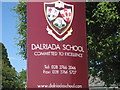
School sign
The Dalriada School sign. Don't ask what the symbols mean, after 40+ years I can't remember.
Image: © Willie Duffin
Taken: 2 Jun 2008
0.14 miles
3
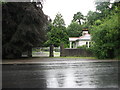
Leslie Hill Estate. Main gate and gate Lodge
A large country estate on the outskirts of Ballymoney. My Grandparents lived here for some time in the early 1900's and my Mother was christened Grace Leslie after one of the Leslie children.
Image: © Willie Duffin
Taken: 5 Aug 2007
0.20 miles
4
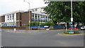
Further Education college
This is the replacement for the old Technical School and is a modern facility with all the latest aids for further education. It is built on the site of the old Model Primary School. It is called The Northern Regional College (NRC).
Image: © Willie Duffin
Taken: 10 May 2008
0.21 miles
5
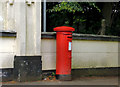
Pillar box, Ballymoney
GR pillar box (BT53 66) outside the former Route Hospital, beside the Coleraine Road.
Image: © Albert Bridge
Taken: 12 Aug 2012
0.22 miles