IMAGES TAKEN NEAR TO
Islandtasserty Road, COLERAINE, BT52 2PW
Introduction
This page details the photographs taken nearby to Islandtasserty Road, BT52 2PW by members of the Geograph project.
The Geograph project started in 2005 with the aim of publishing, organising and preserving representative images for every square kilometre of Great Britain, Ireland and the Isle of Man.

There are currently over 7.5m images from over14,400 individuals and you can help contribute to the project by visiting https://www.geograph.org.uk
Image Map
Images are licensed for reuse under creativecommons.org/licenses/by-sa/2.0
Notes
- Clicking on the map will re-center to the selected point.
- The higher the marker number, the further away the image location is from the centre of the postcode.
Image Listing (5 Images Found)
Images are licensed for reuse under creativecommons.org/licenses/by-sa/2.0
Image
Details
Distance
1
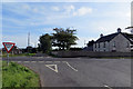
House at the crossroads
Where the Islandtasserty Road crosses the A29.
Image: © Robert Ashby
Taken: 27 Sep 2015
0.13 miles
2
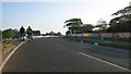
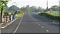
Exit from Mathers Cross
Leaving Mathers and heading through Dundooan towards Portrush.Image
Image: © Willie Duffin
Taken: 16 May 2008
0.16 miles
3
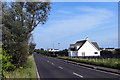
Near Coleraine
A pristine white house on the A29 between Portrush and Coleraine.
Image: © Robert Ashby
Taken: 27 Sep 2015
0.20 miles
4
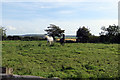
Ebony and ivory
A black horse and a white horse in a field beside the A29.
Image: © Robert Ashby
Taken: 27 Sep 2015
0.20 miles
5
Mathers Cross
The approach to Mathers Cross a very fast right-hand bend. I was sadly unaware at the time (5.30a.m.) but Robert Dunlop had been killed the previous evening during race practice at this corner. Robert was a very well known and respected member of the motorcycle fraternity and brother of the equally famous Joey.
Image
Image: © Willie Duffin
Taken: 16 May 2008
0.22 miles