IMAGES TAKEN NEAR TO
Shell Hill Mews, COLERAINE, BT52 2JJ
Introduction
This page details the photographs taken nearby to Shell Hill Mews, BT52 2JJ by members of the Geograph project.
The Geograph project started in 2005 with the aim of publishing, organising and preserving representative images for every square kilometre of Great Britain, Ireland and the Isle of Man.

There are currently over 7.5m images from over14,400 individuals and you can help contribute to the project by visiting https://www.geograph.org.uk
Image Map
Images are licensed for reuse under creativecommons.org/licenses/by-sa/2.0
Notes
- Clicking on the map will re-center to the selected point.
- The higher the marker number, the further away the image location is from the centre of the postcode.
Image Listing (7 Images Found)
Images are licensed for reuse under creativecommons.org/licenses/by-sa/2.0
Image
Details
Distance
1
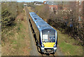
Portrush train near Coleraine
C4K set 4003 approaching Shell Hill Bridge Image with the 12.05 Portrush – Belfast Gt Victoria Street. The train had picked up a substantial number of students at University station Image (background).
Image: © Albert Bridge
Taken: 15 Feb 2013
0.04 miles
2
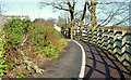
Path and cycle lane, Coleraine
Path and bicycle lane immediately on the Portrush side of this footbridge Image
Image: © Albert Bridge
Taken: 15 Feb 2013
0.07 miles
3
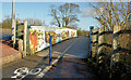
Footbridge, Coleraine
A footbridge, on the Coleraine – Portrush road (Atlantic Road on the Google map) allowing pedestrians and cyclists to avoid the narrow Shell Hill Bridge Image (left).
Image: © Albert Bridge
Taken: 15 Feb 2013
0.08 miles
4
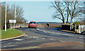
The Shell Hill Bridge, Coleraine
A skew bridge carrying the Coleraine (right) – Portrush road (Atlantic Road on the Google map) across the Coleraine – Portrush railway. Also part of the course of the North West 200 motor cycle race Image The Cromore Road (the back road into Portstewart) is on the left.
Image: © Albert Bridge
Taken: 15 Feb 2013
0.08 miles
5
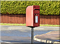
Letter box, Ballysally, Coleraine
Post-mounted EIIR letter box (BT52 160) at Elms Park on the Portrush Road (Atlantic Road on the Google map).
Image: © Albert Bridge
Taken: 15 Feb 2013
0.21 miles
6
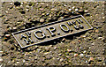
GPO access cover, Coleraine
See Image This one is on the eastern side of the Portrush Road, about half way between the Portstewart and Cromore Roads. Not to be confused with Image
Image: © Albert Bridge
Taken: 15 Feb 2013
0.24 miles
7
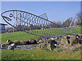
The one that got away!!!
Sculpture at Coleraine Borough Council Offices, Coleraine
Image: © David Laverty
Taken: 19 Mar 2009
0.24 miles