IMAGES TAKEN NEAR TO
Beechfield Drive, COLERAINE, BT52 2HX
Introduction
This page details the photographs taken nearby to Beechfield Drive, BT52 2HX by members of the Geograph project.
The Geograph project started in 2005 with the aim of publishing, organising and preserving representative images for every square kilometre of Great Britain, Ireland and the Isle of Man.

There are currently over 7.5m images from over14,400 individuals and you can help contribute to the project by visiting https://www.geograph.org.uk
Image Map
Images are licensed for reuse under creativecommons.org/licenses/by-sa/2.0
Notes
- Clicking on the map will re-center to the selected point.
- The higher the marker number, the further away the image location is from the centre of the postcode.
Image Listing (2 Images Found)
Images are licensed for reuse under creativecommons.org/licenses/by-sa/2.0
Image
Details
Distance
1
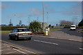
Ballycastle Road roundabout, Coleraine
See Image This is the roundabout on the Ballycastle Road with the ring road in the foreground and the road from Ballycastle at middle right. The grid line cuts across the entrance to the Ballycastle Road. Most of the roundabout, is however, in this square.
Image: © Albert Bridge
Taken: 22 Mar 2007
0.16 miles
2
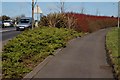
Cycle path, Coleraine ring road.
See Image There is a cycle path which allows cyclists from the Ballycastle direction, heading along the ring road, to avoid the roundabout. The ring road is on the left and the road from Ballycastle is outside the photo at top right.
Image: © Albert Bridge
Taken: 22 Mar 2007
0.16 miles