IMAGES TAKEN NEAR TO
Ballycastle Road, COLERAINE, BT52 2DZ
Introduction
This page details the photographs taken nearby to Ballycastle Road, BT52 2DZ by members of the Geograph project.
The Geograph project started in 2005 with the aim of publishing, organising and preserving representative images for every square kilometre of Great Britain, Ireland and the Isle of Man.

There are currently over 7.5m images from over14,400 individuals and you can help contribute to the project by visiting https://www.geograph.org.uk
Image Map
Images are licensed for reuse under creativecommons.org/licenses/by-sa/2.0
Notes
- Clicking on the map will re-center to the selected point.
- The higher the marker number, the further away the image location is from the centre of the postcode.
Image Listing (34 Images Found)
Images are licensed for reuse under creativecommons.org/licenses/by-sa/2.0
Image
Details
Distance
1
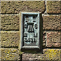
Flush Bracket, Coleraine
Flush bracket bench mark on the north-eastern tip of a former biscuit factory on the Ballycastle Road in Coleraine (now a printworks).
The number on the bracket is OSBM 3431.
The mark has been levelled to 14.77 metres above MSL.
Image: © Rossographer
Taken: 29 May 2023
0.07 miles
2
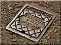
"Crawford" access cover, Coleraine (1)
There are several small access covers along the Ballycastle Road. This is one of two, to two different designs, opposite the Sperrin Business Park. Both are marked “T Crawford & Sons, Coleraine”. Crawford is a common name in the area. I cannot find any trace of a foundry under that name but there were Thos Crawford, plumber in Stone Row and Crawford & Co, hardware warehouse in The Diamond, around 100 years ago. Image shows the other.
Image: © Albert Bridge
Taken: 4 Apr 2012
0.07 miles
3
"Crawford" access cover, Coleraine (2)
See Image The second – very close to the first.
Image: © Albert Bridge
Taken: 4 Apr 2012
0.08 miles
4
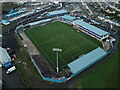
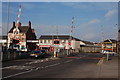
Coleraine Showgrounds
Home of Coleraine Football Club, The showgrounds at Ballycastle Road Coleraine.
Image: © KS
Taken: 5 Dec 2021
0.16 miles
5
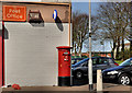
Pillar box, Coleraine
EIIR pillar box (BT52 156) at Harper’s Hill post office on the Ballycastle Road.
Image: © Albert Bridge
Taken: 4 Apr 2012
0.17 miles
6
Level crossing, Coleraine station
Coleraine station is where the branch to Portrush leaves the Belfast-Londonderry line. The level crossing at the northern of the station is a full-barrier one controlled locally by the signalman. The Railway Road to the town centre is on the left, the Bushmills Road on the right and the Ballycastle Road in the foreground.
Image: © Albert Bridge
Taken: 14 Oct 2006
0.19 miles
7
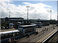
Ulsterbus maintenance depot, Coleraine
Ulsterbus maintenance depot beside Coleraine railway station.
Image: © Willie Duffin
Taken: 9 Sep 2010
0.19 miles
8
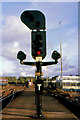
Colour light signal, Coleraine station
Back in the late-1930’s the London Midland and Scottish Railway (Northern Counties Committee), successors to the Belfast and Northern Counties Railway, undertook a major re-signalling of parts of its operation in Northern Ireland. Coleraine station received colour lights in 1938 – of which this up starter was an example. Now replaced.
Image: © Albert Bridge
Taken: 4 Aug 1984
0.21 miles
9
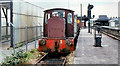
DH locomotive, Coleraine
Part of a class of three intended for shunting and ballast train duties, diesel hydraulic locomotive no 3 at Coleraine. Taken on the same day as Image thanks to the use of a Rail Runabout ticket.
Image: © Albert Bridge
Taken: 16 Jul 1982
0.21 miles
10
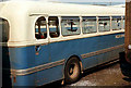
Vandalised bus, Coleraine
A vandalised Ulsterbus (ex-Edinburgh Corporation) Leyland Tiger Cub parked at Coleraine depot. The railway wagon (right) is a brown (parcels/mail) van.
Image: © Albert Bridge
Taken: 4 Aug 1970
0.21 miles