IMAGES TAKEN NEAR TO
Kenvarra Close, COLERAINE, BT52 1XT
Introduction
This page details the photographs taken nearby to Kenvarra Close, BT52 1XT by members of the Geograph project.
The Geograph project started in 2005 with the aim of publishing, organising and preserving representative images for every square kilometre of Great Britain, Ireland and the Isle of Man.

There are currently over 7.5m images from over14,400 individuals and you can help contribute to the project by visiting https://www.geograph.org.uk
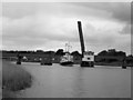
Image Map
Images are licensed for reuse under creativecommons.org/licenses/by-sa/2.0
Notes
- Clicking on the map will re-center to the selected point.
- The higher the marker number, the further away the image location is from the centre of the postcode.
Image Listing (57 Images Found)
Images are licensed for reuse under creativecommons.org/licenses/by-sa/2.0
Image
Details
Distance
1
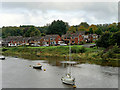
River Bann, Coleraine, Kenvarra Park
The River Bann is the longest river in Northern Ireland. The river winds its way from the southeast corner of Northern Ireland to the northwest coast, widening in the middle into the enormous Lough Neagh.
Image: © David Dixon
Taken: 28 Sep 2017
0.04 miles
2
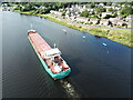
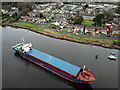
Athos on River Bann
Athos departing Coleraine on the River Bann.
Image: © KS
Taken: 26 Jul 2022
0.09 miles
3
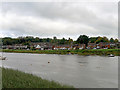
River Bann near Coleraine
The River Bann is the longest river in Northern Ireland. The river winds its way from the southeast corner of Northern Ireland to the northwest coast, widening in the middle into the enormous Lough Neagh.
Image: © David Dixon
Taken: 28 Sep 2017
0.10 miles
4
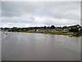
River Bann, Coleraine
The River Bann is the longest river in Northern Ireland. The river winds its way from the southeast corner of Northern Ireland to the northwest coast, widening in the middle into the enormous Lough Neagh.
Image: © David Dixon
Taken: 28 Sep 2017
0.10 miles
5
MV Balmoral at Coleraine
MV Balmoral passes the railway bridge at Coleraine on a special trip.
Image: © The Carlisle Kid
Taken: 7 Jun 2003
0.10 miles
6
Baltica Hav on the River Bann
Baltica Hav on the River Bann en route for Coleraine Harbour
Image: © KS
Taken: 25 Dec 2020
0.10 miles
7
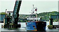
The "Sina B", River Bann, Coleraine (1)
The coaster “Sina B”, outbound with a cargo of scrap for northern Spain, passing through the lifting span of the Bann railway bridge. See also Image
Image: © Albert Bridge
Taken: 13 May 2005
0.11 miles
8
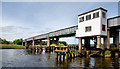
Railway bridge, Coleraine (2)
About to pass under the railway bridge Image The lifting span is the one to the left of the white operating house. The span is electrically powered but can, should circumstances warrant, be operated by hand.
Image: © Albert Bridge
Taken: 12 Jun 2010
0.11 miles
9
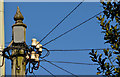
Telephone cables, Coleraine
There are still many places where the telephone cables have not been placed underground. This example is on the Portrush Road, just past the corner of the Portstewart Road.
Image: © Albert Bridge
Taken: 15 Feb 2013
0.14 miles
10
The Bann railway bridge, Coleraine
The 10.45 Londonderry – Belfast York Road crossing the Bann bridge at Coleraine. The train has a parcels/mail van – standard practice then on all Belfast – Londonderry trains. Some Belfast – Coleraine trains hauled one or more (smaller) “brown vans” for parcels.
The riverbank is no longer accessible after houses were built between it and what was then a lane off the Millburn Road.
Image: © Albert Bridge
Taken: 14 Apr 1973
0.14 miles