IMAGES TAKEN NEAR TO
Kildollagh Lane, COLERAINE, BT52 1UG
Introduction
This page details the photographs taken nearby to Kildollagh Lane, BT52 1UG by members of the Geograph project.
The Geograph project started in 2005 with the aim of publishing, organising and preserving representative images for every square kilometre of Great Britain, Ireland and the Isle of Man.

There are currently over 7.5m images from over14,400 individuals and you can help contribute to the project by visiting https://www.geograph.org.uk
Image Map
Images are licensed for reuse under creativecommons.org/licenses/by-sa/2.0
Notes
- Clicking on the map will re-center to the selected point.
- The higher the marker number, the further away the image location is from the centre of the postcode.
Image Listing (8 Images Found)
Images are licensed for reuse under creativecommons.org/licenses/by-sa/2.0
Image
Details
Distance
1
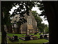
Church at Fish Loughan
Church Of Ireland St Paul's-Kildollagh at Fish Loughan.
Image: © Robert Ashby
Taken: 29 Aug 2013
0.05 miles
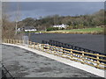
2
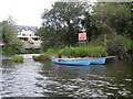
Boats near Loughan Island
Pictured on the Bann
Image: © Kenneth Allen
Taken: 17 Aug 2010
0.10 miles
3
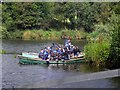
Boating activity on the Bann
Pictured near Loughan Island
Image: © Kenneth Allen
Taken: 17 Aug 2010
0.11 miles
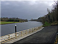
4
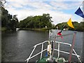
Loughan Island
Navigating north-west towards Colerains
Image: © Kenneth Allen
Taken: 17 Aug 2010
0.11 miles
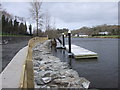
5
Jetty, Camus Picnic Area, Camus, Coleraine.
New jetty at Camus Picnic Area, Camus, Coleraine (built Nov08/March 09).
Image: © David Laverty
Taken: 14 Mar 2009
0.19 miles
6
Jetty, Camus Picnic Area, Camus, Coleraine.
Image: © David Laverty
Taken: 14 Mar 2009
0.19 miles
7
Jetty, Camus Picnic Area, Camus, Coleraine.
Image: © David Laverty
Taken: 14 Mar 2009
0.19 miles
8
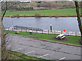
Jetty, Camus Picnic Area, Camus, Coleraine.
New jetty at Camus Picnic Area, Camus, Coleraine. (Built Nov08/Mar09)
Image: © David Laverty
Taken: 14 Mar 2009
0.20 miles