IMAGES TAKEN NEAR TO
Drumslade Road, COLERAINE, BT52 1SE
Introduction
This page details the photographs taken nearby to Drumslade Road, BT52 1SE by members of the Geograph project.
The Geograph project started in 2005 with the aim of publishing, organising and preserving representative images for every square kilometre of Great Britain, Ireland and the Isle of Man.

There are currently over 7.5m images from over14,400 individuals and you can help contribute to the project by visiting https://www.geograph.org.uk
Image Map
Images are licensed for reuse under creativecommons.org/licenses/by-sa/2.0
Notes
- Clicking on the map will re-center to the selected point.
- The higher the marker number, the further away the image location is from the centre of the postcode.
Image Listing (5 Images Found)
Images are licensed for reuse under creativecommons.org/licenses/by-sa/2.0
Image
Details
Distance
1
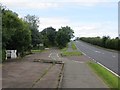
Portstewart Road
The cycle path swerves around a bus stop on the A2.
Image: © Richard Webb
Taken: 4 Aug 2013
0.16 miles
2
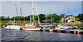
Seaton's marina, River Bann near Coleraine
Privately-owned marina, on the eastern side of the Bann.
Image: © Albert Bridge
Taken: 12 Jun 2010
0.18 miles
3
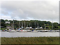
River Bann, Seaton's Marina
The River Bann is the longest river in Northern Ireland. The river winds its way from the southeast corner of Northern Ireland to the northwest coast, widening in the middle into the enormous Lough Neagh.
Image: © David Dixon
Taken: 28 Sep 2017
0.19 miles
4
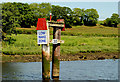
Navigation marker, River Bann near Coleraine
Port side marker downstream of Seaton’s marina Image
Image: © Albert Bridge
Taken: 12 Jun 2010
0.21 miles