IMAGES TAKEN NEAR TO
Riversdale Crescent, COLERAINE, BT52 1QU
Introduction
This page details the photographs taken nearby to Riversdale Crescent, BT52 1QU by members of the Geograph project.
The Geograph project started in 2005 with the aim of publishing, organising and preserving representative images for every square kilometre of Great Britain, Ireland and the Isle of Man.

There are currently over 7.5m images from over14,400 individuals and you can help contribute to the project by visiting https://www.geograph.org.uk
Image Map
Images are licensed for reuse under creativecommons.org/licenses/by-sa/2.0
Notes
- Clicking on the map will re-center to the selected point.
- The higher the marker number, the further away the image location is from the centre of the postcode.
Image Listing (157 Images Found)
Images are licensed for reuse under creativecommons.org/licenses/by-sa/2.0
Image
Details
Distance
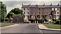
1
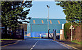
Harbour gate, Coleraine
The Riversdale Gate, Millburn Road, is the only means of vehicular access to Coleraine harbour http://www.geograph.org.uk/snippet/4598.
Image: © Albert Bridge
Taken: 15 Feb 2013
0.04 miles
2
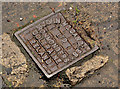
John McCandless access cover, Coleraine
See http://www.geograph.org.uk/search.php?i=32731011. Another one from a local ironmonger. This one is on the Millburn Road and has the inscription “John McCandless Ltd Ironmongers Coleraine Ireland”. The company seems to have traded from 10 Church Street in the early 20th century and might still exist, albeit as part of a larger group.
Image: © Albert Bridge
Taken: 29 Jun 2012
0.04 miles
3
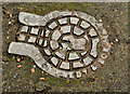
Kennedy access cover, Coleraine
A small and well-worn access cover on the Millburn Road. The inscription shows that it was made by H Kennedy & Sons, ironfounders and agricultural engineers, who traded from Coleraine in the late 19th and early 20th century.
Image: © Albert Bridge
Taken: 3 Aug 2012
0.04 miles
4
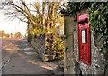
Letter box, Coleraine
Wall-mounted EIIR letter box, on the Millburn Road, almost opposite the entrance to the harbour.
Image: © Albert Bridge
Taken: 14 Nov 2011
0.05 miles
5
Old harbour railway, Coleraine (3)
An overgrown and disused section of the old goods line to Coleraine harbour, between Image and Image, on the Millburn Road opposite the Riversdale gate. Much of it has now gone but the small remaining part can be seen (background) in Image
Image: © Albert Bridge
Taken: 7 Jun 1980
0.05 miles
6
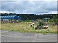
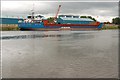
Brownfield site, Coleraine
What appears to be a factory site off Millburn Road.
Image: © Richard Webb
Taken: 4 Aug 2013
0.08 miles
7
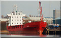
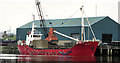
The "Maja" at Coleraine
The coaster “Maja”, discharging a cargo of chipboard. Most of the ships visiting Coleraine harbour are low-air draught – seeing a “real” ship was quite a surprise.
Image: © Albert Bridge
Taken: 8 Feb 2007
0.10 miles
8
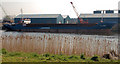
The "Defender" at Coleraine
The coaster “Defender” at Coleraine where she had discharged steel coil – a cargo which, after a promising start, seemed to vanish.
Image: © Albert Bridge
Taken: 31 Mar 2007
0.10 miles
9
Discharging at Coleraine harbour
See Image The same ship but discharging a cargo of steel coil.
Image: © Albert Bridge
Taken: 5 Jul 2007
0.10 miles
10
The "Salina II" at Coleraine
At 35 metres, the “Salina II” was one of the smaller ships to visit Coleraine in recent times. She had loaded building materials for the west of Scotland.
Image: © Albert Bridge
Taken: 29 Apr 2000
0.10 miles