IMAGES TAKEN NEAR TO
Union Street, COLERAINE, BT52 1QB

Introduction

This page details the photographs taken nearby to Union Street, BT52 1QB by members of the Geograph project.

The Geograph project started in 2005 with the aim of publishing, organising and preserving representative images for every square kilometre of Great Britain, Ireland and the Isle of Man.

There are currently over 7.5m images from over14,400 individuals and you can help contribute to the project by visiting https://www.geograph.org.uk

Image Map


Images are licensed for reuse under creativecommons.org/licenses/by-sa/2.0
Notes
  • Clicking on the map will re-center to the selected point.
  • The higher the marker number, the further away the image location is from the centre of the postcode.

Image Listing (215 Images Found)

Images are licensed for reuse under creativecommons.org/licenses/by-sa/2.0
  • ...
Image
Details
Distance
1
Swilly coach, Coleraine (July 1991)
A Londonderry & Lough Swilly Railway Plaxton-bodied Volvo coach (DUI 257) parked at Union Street.
Image: © Albert Bridge Taken: 6 Jul 1991
0.02 miles
2
Moore's drain cover, Coleraine
See Image A Moore’s foundry drain cover at the railway end of Union Street.
Image: © Albert Bridge Taken: 14 Nov 2011
0.02 miles
3
Old harbour railway, Coleraine (1)
See Image This stretch of old railway (mentioned in the caption) has an interesting history. It opened in 1860 as part of the line between Belfast York Road and Londonderry Waterside. At the time Coleraine station occupied a site at the Waterside on the western side of the Bann. The Bann Bridge Image, together with a realigned stretch of railway, opened 1924 leaving the line as a goods-only branch serving the harbour. It eventually fell into disuse in 1963 before being lifted circa 1966 and is now mostly built over. The view is from Brook Street towards the present station Image in Railway Road.
Image: © Albert Bridge Taken: 13 Jul 1982
0.03 miles
4
Martin's Brae, Coleraine
A steep street running from the Circular Road (out of picture – foreground) to Union Street.
Image: © Albert Bridge Taken: 4 Apr 2012
0.04 miles
5
Gospel Hall, Coleraine
Gospel Hall at the Union Street end of Brook Street.
Image: © Albert Bridge Taken: 29 Feb 2012
0.05 miles
6
Circular Road, Coleraine
Looking towards the Brook Street junction.
Image: © Willie Duffin Taken: 9 Apr 2012
0.06 miles
7
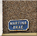
Martins Brae sign, Coleraine
Cast sign at the Circular Road end of Martins Brae Image
Image: © Albert Bridge Taken: 29 Feb 2012
0.06 miles
8
Union Street
Union street with our next target being Bushmills, the place of the whiskey distillery. The bunting flying between the lamp posts is Union Jack flags, which I suppose is not surprising in this area.
Image: © Malcolm Neal Taken: 27 Jul 2022
0.06 miles
9
Cavanagh stop valve cover, Coleraine
A small Cavanagh cover, over what might be a stop valve, at the Railway Road end of the Circular Road.
Image: © Albert Bridge Taken: 11 May 2012
0.06 miles
10
Stop valve cover, Coleraine
A small anonymous cover, over what might be a stop valve, on the Circular Road, close to Martin’s Brae Image
Image: © Albert Bridge Taken: 11 May 2012
0.06 miles
  • ...