IMAGES TAKEN NEAR TO
Nursery Avenue, COLERAINE, BT52 1LR
Introduction
This page details the photographs taken nearby to Nursery Avenue, BT52 1LR by members of the Geograph project.
The Geograph project started in 2005 with the aim of publishing, organising and preserving representative images for every square kilometre of Great Britain, Ireland and the Isle of Man.

There are currently over 7.5m images from over14,400 individuals and you can help contribute to the project by visiting https://www.geograph.org.uk
Image Map
Images are licensed for reuse under creativecommons.org/licenses/by-sa/2.0
Notes
- Clicking on the map will re-center to the selected point.
- The higher the marker number, the further away the image location is from the centre of the postcode.
Image Listing (128 Images Found)
Images are licensed for reuse under creativecommons.org/licenses/by-sa/2.0
Image
Details
Distance
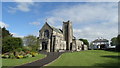
2
St. Malachy's RC Church, Coleraine
Looking south-east from Beresford Road
Image: © Kenneth Allen
Taken: 24 Aug 2024
0.02 miles
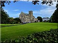
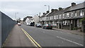
3
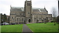
St.Malachys Catholic Church, Coleraine
Looking East from the car-park on Beresford Avenue
Image: © Willie Duffin
Taken: 11 Mar 2012
0.04 miles
4
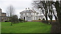
St.Malachys parochial house
The parochial house in the grounds of the church.
Image: © Willie Duffin
Taken: 11 Mar 2012
0.04 miles
5
BT building Coleraine
Rear entrance to BT headquarters Coleraine.
Image: © Willie Duffin
Taken: 8 Mar 2012
0.05 miles
6
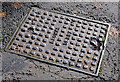
"Browns" (Foyle Foundry) access cover, Coleraine
An access cover, in Beresford Avenue, made by A Brown & Sons Ltd, the Foyle and Wellington Foundries, who traded from Foyle Street in the early part of the last century.
Image: © Albert Bridge
Taken: 31 Oct 2012
0.07 miles
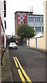
7
Nursery Avenue Coleraine
Looking in the town centre direction.
Image: © Willie Duffin
Taken: 8 Mar 2012
0.07 miles
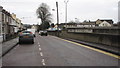
8
Beresford Avenue, Coleraine
Looking South towards St.Johns secondary school.
Image: © Willie Duffin
Taken: 11 Mar 2012
0.07 miles
9
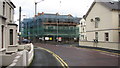
Lerwill House Care Home
This site on the corner of Nursery Avenue/Adelaide Avenue is being developed by The Triangle Housing Association. It is replacing the original building which had outgrown its capacity. The new premises will provide sheltered accommodation in 10x1 bed apartments and 2x2 bed apartments.
Image: © Willie Duffin
Taken: 8 Mar 2012
0.07 miles
10
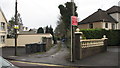
Laneway off Nursery Avenue
This laneway services the rear of dwellings on Adelaide Avenue.
Image: © Willie Duffin
Taken: 8 Mar 2012
0.07 miles