IMAGES TAKEN NEAR TO
Culmore Gardens, COLERAINE, BT52 1JP
Introduction
This page details the photographs taken nearby to Culmore Gardens, BT52 1JP by members of the Geograph project.
The Geograph project started in 2005 with the aim of publishing, organising and preserving representative images for every square kilometre of Great Britain, Ireland and the Isle of Man.

There are currently over 7.5m images from over14,400 individuals and you can help contribute to the project by visiting https://www.geograph.org.uk
Image Map
Images are licensed for reuse under creativecommons.org/licenses/by-sa/2.0
Notes
- Clicking on the map will re-center to the selected point.
- The higher the marker number, the further away the image location is from the centre of the postcode.
Image Listing (6 Images Found)
Images are licensed for reuse under creativecommons.org/licenses/by-sa/2.0
Image
Details
Distance
2
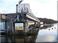
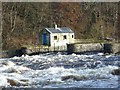
The Salmon Leap (The Cutts), Castleroe, Coleraine.
The Salmon Leap. Coleraine on the River Bann.
Image: © David Laverty
Taken: 8 Mar 2009
0.21 miles
3
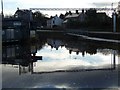
The Bann, Castleroe
Looking north-west
Image: © Kenneth Allen
Taken: 22 Jun 2011
0.21 miles
5
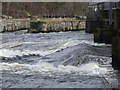
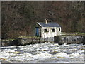
The Salmon Leap (The Cutts), Castleroe, Coleraine.
Wonderful location to see the force at which the River Bann flows, as it heads on its final journey to the Atlantic Ocean.
Image: © David Laverty
Taken: 8 Mar 2009
0.24 miles