IMAGES TAKEN NEAR TO
Mount Street Mews, COLERAINE, BT52 1HP
Introduction
This page details the photographs taken nearby to Mount Street Mews, BT52 1HP by members of the Geograph project.
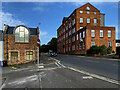
The Geograph project started in 2005 with the aim of publishing, organising and preserving representative images for every square kilometre of Great Britain, Ireland and the Isle of Man.

There are currently over 7.5m images from over14,400 individuals and you can help contribute to the project by visiting https://www.geograph.org.uk
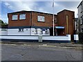
Image Map
Images are licensed for reuse under creativecommons.org/licenses/by-sa/2.0
Notes
- Clicking on the map will re-center to the selected point.
- The higher the marker number, the further away the image location is from the centre of the postcode.
Image Listing (152 Images Found)
Images are licensed for reuse under creativecommons.org/licenses/by-sa/2.0
Image
Details
Distance
1
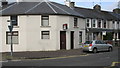
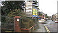
Angular building, Beresford Avenue
An angular building divided into separate units at the junction of Beresford Ave./Mount Street.
Image: © Willie Duffin
Taken: 11 Mar 2012
0.03 miles
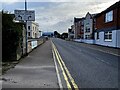
2
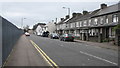
Beresford Avenue, Coleraine
Looking South towards St.Johns secondary school.
Image: © Willie Duffin
Taken: 11 Mar 2012
0.03 miles
3
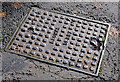
"Browns" (Foyle Foundry) access cover, Coleraine
An access cover, in Beresford Avenue, made by A Brown & Sons Ltd, the Foyle and Wellington Foundries, who traded from Foyle Street in the early part of the last century.
Image: © Albert Bridge
Taken: 31 Oct 2012
0.04 miles
4
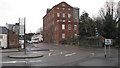
Beresford House
A former shirt factory now used as an office block for various organisations.
Image: © Willie Duffin
Taken: 8 Mar 2012
0.04 miles
5
Plaque at Beresford House
Information plaque at the entrance to Beresford House.
Image: © Willie Duffin
Taken: 8 Mar 2012
0.04 miles
6
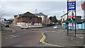
Royal British Legion, Coleraine
The British Legion building at the junction of Terrace Row/Beresford Road.
Image: © Willie Duffin
Taken: 11 Mar 2012
0.05 miles
7
Beresford House
Looking from the car-park on Beresford Avenue. This is a former shirt factory now renovated with the addition of some extra accommodation at the rear. It is now used as an office building by several organisations.
Image: © Willie Duffin
Taken: 11 Mar 2012
0.05 miles
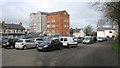
9
Beresford Road, Coleraine
The building on the right was a former shirt factory, later converted to offices and apartments and now for sale
Image: © Kenneth Allen
Taken: 24 Aug 2024
0.05 miles
10
Royal British Legion, Coleraine
Pictured along Beresford Road
Image: © Kenneth Allen
Taken: 24 Aug 2024
0.05 miles