IMAGES TAKEN NEAR TO
Lime Market Street, COLERAINE, BT52 1HD
Introduction
This page details the photographs taken nearby to Lime Market Street, BT52 1HD by members of the Geograph project.
The Geograph project started in 2005 with the aim of publishing, organising and preserving representative images for every square kilometre of Great Britain, Ireland and the Isle of Man.

There are currently over 7.5m images from over14,400 individuals and you can help contribute to the project by visiting https://www.geograph.org.uk
Image Map
Images are licensed for reuse under creativecommons.org/licenses/by-sa/2.0
Notes
- Clicking on the map will re-center to the selected point.
- The higher the marker number, the further away the image location is from the centre of the postcode.
Image Listing (263 Images Found)
Images are licensed for reuse under creativecommons.org/licenses/by-sa/2.0
Image
Details
Distance
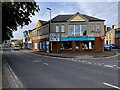
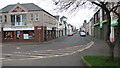
1
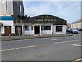
Coopers, Coleraine
Pictured at Lime Market Street
Image: © Kenneth Allen
Taken: 24 Aug 2024
0.00 miles
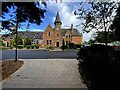
2
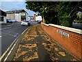
Beresford Road, Coleraine
Heading east
Image: © Kenneth Allen
Taken: 24 Aug 2024
0.01 miles
3
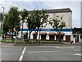
Homemakers, Coleraine
Pictured along Beresford Road
Image: © Kenneth Allen
Taken: 24 Aug 2024
0.01 miles
4
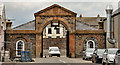
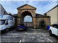
The Market Yard, Coleraine
The long-disused market yard of 1829 is nearing the end of a major restoration. When complete it is expected to house the Coleraine museum – currently using the town hall.
This archway, in Lime Market Street, includes a replacement and relocated curfew bell “The bell was rung to call the arms at times of political unrest and to denote curfew time. Later it was used to inform townsfolk of local court sittings and the hour of the day. The original bell was replaced and relocated to hang over the entrance to the Market Yard in Lime Market Street where it hangs to this day” – a quotation from this site http://www.northcoastni.com/explore/coleraine/ .
Image: © Albert Bridge
Taken: 29 Feb 2012
0.02 miles
5
Brick archway, Coleraine
Pictured along Lime Market Street, it leads to the former market yard.
More at Image]
Image: © Kenneth Allen
Taken: 24 Aug 2024
0.02 miles
6
Beresford Place, Coleraine
Looking east
Image: © Kenneth Allen
Taken: 24 Aug 2024
0.02 miles
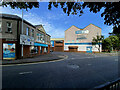
7
Former primary school, Coleraine
Looking SSE from Beresford Road
Image: © Kenneth Allen
Taken: 24 Aug 2024
0.03 miles
8
Cancer Focus NI, Coleraine
Pictured at Blindgate Street
Image: © Kenneth Allen
Taken: 24 Aug 2024
0.03 miles
9
Dunmore Street, Coleraine
Dunmore Street just before it joins Blindgate Street on the left.
Image: © Willie Duffin
Taken: 11 Mar 2012
0.03 miles
10
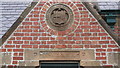
Wall plaque
Plaque above door of The Irish Society School. The door is the "Infants" entrance and the plaque reads Rose-Governor/ Truscott-Dep.Governor.
Image: © Willie Duffin
Taken: 11 Mar 2012
0.04 miles