IMAGES TAKEN NEAR TO
Boilingwell Lane, COLERAINE, BT52 1GD
Introduction
This page details the photographs taken nearby to Boilingwell Lane, BT52 1GD by members of the Geograph project.
The Geograph project started in 2005 with the aim of publishing, organising and preserving representative images for every square kilometre of Great Britain, Ireland and the Isle of Man.

There are currently over 7.5m images from over14,400 individuals and you can help contribute to the project by visiting https://www.geograph.org.uk
Image Map
Images are licensed for reuse under creativecommons.org/licenses/by-sa/2.0
Notes
- Clicking on the map will re-center to the selected point.
- The higher the marker number, the further away the image location is from the centre of the postcode.
Image Listing (290 Images Found)
Images are licensed for reuse under creativecommons.org/licenses/by-sa/2.0
Image
Details
Distance
1
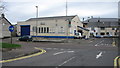
Triangle Snooker Hall
Snooker club on Long Commons, Coleraine.
Image: © Willie Duffin
Taken: 11 Mar 2012
0.04 miles
2

Sailor Bill, Coleraine
Tattoo artists shop at the junction of Taylors Row and Long Commons.
Image: © Willie Duffin
Taken: 11 Mar 2012
0.04 miles
3
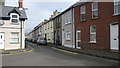
Taylors Row ,Coleraine
Row of small terraced houses.
Image: © Willie Duffin
Taken: 11 Mar 2012
0.05 miles
4
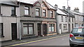
Terrace houses, Coleraine
I was intrigued by these two houses on Long Commons. They seemed out of keeping with the rest of the row which were all roughly of the same 20's/30's standard.
Image: © Willie Duffin
Taken: 11 Mar 2012
0.07 miles
5
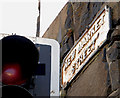
New Market Street sign, Coleraine
Cast sign, attached to the wall of the old Market Yard, at the Long Commons end of New Market Street.
Image: © Albert Bridge
Taken: 7 Jan 2011
0.07 miles
6

Bricked-up building, Coleraine
This solid stone building in the access lane at the rear of New Market Street has what looks like an annex for a hoist of some sort. This possibly dates back to time when many buildings in this area were involved in the brewing industry.
Image: © Willie Duffin
Taken: 11 Mar 2012
0.07 miles
7
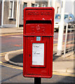
Postbox, Coleraine
Image: © Albert Bridge
Taken: 7 Jan 2011
0.07 miles
8
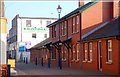
Society Street, Coleraine (part)
Society Street looking towards Church Street. The “Society” being the Honourable the Irish Society for the Plantation of Ulster. It was responsible for the planning and development of Coleraine in the 17th century.
Image: © Albert Bridge
Taken: 25 Oct 2007
0.09 miles
9
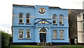
Masonic Hall, Coleraine (1)
Decorated Masonic Hall on the Lodge Road. No date of building but the foundation stone was laid in 1886. Continue to Image
Image: © Albert Bridge
Taken: 29 Feb 2012
0.09 miles
10
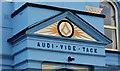
Masonic Hall. Coleraine (2)
See Image The pediment, above the entrance, incorporating the square and the motto AUDI VIDE TACE – “hear see be silent”. Continue to Image
Image: © Albert Bridge
Taken: 29 Feb 2012
0.09 miles