IMAGES TAKEN NEAR TO
The Cranagh, Cromore Road, COLERAINE, BT52 1EU
Introduction
This page details the photographs taken nearby to The Cranagh, Cromore Road, BT52 1EU by members of the Geograph project.
The Geograph project started in 2005 with the aim of publishing, organising and preserving representative images for every square kilometre of Great Britain, Ireland and the Isle of Man.

There are currently over 7.5m images from over14,400 individuals and you can help contribute to the project by visiting https://www.geograph.org.uk
Image Map
Images are licensed for reuse under creativecommons.org/licenses/by-sa/2.0
Notes
- Clicking on the map will re-center to the selected point.
- The higher the marker number, the further away the image location is from the centre of the postcode.
Image Listing (369 Images Found)
Images are licensed for reuse under creativecommons.org/licenses/by-sa/2.0
Image
Details
Distance
1
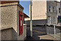
Letter box, Coleraine
Wall-mounted EIIR box (BT52 7 – officially Ferryquay Street) at the Ferryquay Place end of Abbey Street Image (background, right).
Image: © Albert Bridge
Taken: 4 Apr 2012
0.03 miles
2
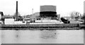
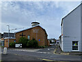
Coleraine gasworks
Coleraine gasworks, at Hanover Place, opened in 1845 producing town gas from coal. In 1967 it converted to gas production from naphtha imported, by ship, through a jetty Image further downstream on the Bann. In common with all town gasworks in Northern Ireland it closed. After a long gap natural gas is now available through pipelines from Scotland and the Republic of Ireland. The area was subsequently redeveloped Image but in the days before riverside apartments became the norm.
Image: © Albert Bridge
Taken: 1 Mar 1980
0.03 miles
3
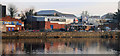
Former gasworks site, Coleraine
The site of the former gasworks Image, at Hanover Place, after redevelopment.
Image: © Albert Bridge
Taken: 7 Jan 2011
0.03 miles
4
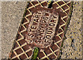
Stewart's drain cover, Coleraine
A Stewart’s Sandy Row foundry, Belfast http://www.geograph.org.uk/search.php?i=30070908 drain cover at the southern end of Abbey Street Image
Image: © Albert Bridge
Taken: 4 Apr 2012
0.03 miles
5
Coleraine Baptist Church
Pictured along Stone Row
Image: © Kenneth Allen
Taken: 24 Aug 2024
0.04 miles
6
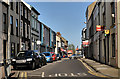
Abbey Street, Coleraine
A street running from Dunmore Street to The Diamond (background). It takes its name from a Dominican Abbey founded in 1244 and dissolved in the 1530’s.
Image: © Albert Bridge
Taken: 4 Apr 2012
0.04 miles
7
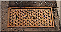
PKS fire hydrant cover, Coleraine
Image: © Albert Bridge
Taken: 7 Jan 2011
0.04 miles
8
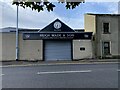
Hugh Wade & Son, Coleraine
Pictured along Bannfield Road
Image: © Kenneth Allen
Taken: 24 Aug 2024
0.05 miles
10
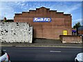
Kwik Fit, Coleraine
Pictured along Hanover Place
Image: © Kenneth Allen
Taken: 24 Aug 2024
0.06 miles