IMAGES TAKEN NEAR TO
Edenbane Road, COLERAINE, BT51 5XF
Introduction
This page details the photographs taken nearby to Edenbane Road, BT51 5XF by members of the Geograph project.
The Geograph project started in 2005 with the aim of publishing, organising and preserving representative images for every square kilometre of Great Britain, Ireland and the Isle of Man.

There are currently over 7.5m images from over14,400 individuals and you can help contribute to the project by visiting https://www.geograph.org.uk
Image Map
Images are licensed for reuse under creativecommons.org/licenses/by-sa/2.0
Notes
- Clicking on the map will re-center to the selected point.
- The higher the marker number, the further away the image location is from the centre of the postcode.
Image Listing (4 Images Found)
Images are licensed for reuse under creativecommons.org/licenses/by-sa/2.0
Image
Details
Distance
1
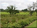
Farmland, Edenbane Road
One field is rather better drained than the other. Outside Kilrea on the B64.
Image: © Richard Webb
Taken: 30 Jul 2013
0.11 miles
2
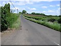
Blackrock Road
Heading east towards Kilrea
Image: © Kenneth Allen
Taken: 9 Jun 2008
0.16 miles
4
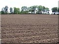
Drumane Townland
The potatoes haven't broken through the ridges yet.
Image: © Kenneth Allen
Taken: 9 Jun 2008
0.24 miles