IMAGES TAKEN NEAR TO
Beechgrove, COLERAINE, BT51 5RW
Introduction
This page details the photographs taken nearby to Beechgrove, BT51 5RW by members of the Geograph project.
The Geograph project started in 2005 with the aim of publishing, organising and preserving representative images for every square kilometre of Great Britain, Ireland and the Isle of Man.

There are currently over 7.5m images from over14,400 individuals and you can help contribute to the project by visiting https://www.geograph.org.uk
Image Map
Images are licensed for reuse under creativecommons.org/licenses/by-sa/2.0
Notes
- Clicking on the map will re-center to the selected point.
- The higher the marker number, the further away the image location is from the centre of the postcode.
Image Listing (35 Images Found)
Images are licensed for reuse under creativecommons.org/licenses/by-sa/2.0
Image
Details
Distance
1
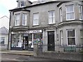
Fairhill Veterinary Centre, Kilrea
Looking south-east
Image: © Kenneth Allen
Taken: 23 Jun 2008
0.12 miles
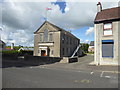
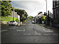
2
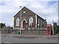
Second Kilrea Presbyterian Church
It is located at the west end of the town
Image: © Kenneth Allen
Taken: 23 Jun 2008
0.13 miles
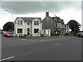
3
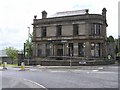
Northern Bank, Kilrea
It is located at the west of the town
Image: © Kenneth Allen
Taken: 23 Jun 2008
0.13 miles
4
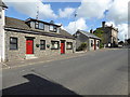
Cottages, Kilrea
Located along New Row
Image: © Kenneth Allen
Taken: 20 Jul 2017
0.13 miles
5
Kilrea Orange Hall
Pictured along New Row
Image: © Kenneth Allen
Taken: 20 Jul 2017
0.13 miles
6
SVP Thrift Shop & Drop-in Centre, Kilrea
Looking WSW
Image: © Kenneth Allen
Taken: 22 Jun 2011
0.14 miles
7
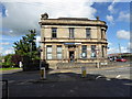
Danske Bank, Kilrea
Pictured at New Row / Maghera Road
Image: © Kenneth Allen
Taken: 20 Jul 2017
0.15 miles
8
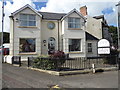
SVP, Kilrea
Pictured along Maghera Street
Image: © Kenneth Allen
Taken: 20 Jul 2017
0.15 miles
9
New Road, Kilrea
Near the town centre.
Image: © Dean Molyneaux
Taken: 23 Aug 2009
0.16 miles
10
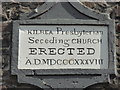
Plaque, Kilrea Presbyterian Seceding Church
Pictured here Image]
Image: © Kenneth Allen
Taken: 20 Jul 2017
0.17 miles