IMAGES TAKEN NEAR TO
Bann Road, COLERAINE, BT51 5RU
Introduction
This page details the photographs taken nearby to Bann Road, BT51 5RU by members of the Geograph project.
The Geograph project started in 2005 with the aim of publishing, organising and preserving representative images for every square kilometre of Great Britain, Ireland and the Isle of Man.

There are currently over 7.5m images from over14,400 individuals and you can help contribute to the project by visiting https://www.geograph.org.uk
Image Map
Images are licensed for reuse under creativecommons.org/licenses/by-sa/2.0
Notes
- Clicking on the map will re-center to the selected point.
- The higher the marker number, the further away the image location is from the centre of the postcode.
Image Listing (2 Images Found)
Images are licensed for reuse under creativecommons.org/licenses/by-sa/2.0
Image
Details
Distance
1
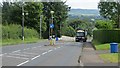
Bann Road, Kilrea
A refuse truck climbing up the Bann Road. Crossing the Bann is a big moment, but the problem with crossing big rivers is the sure knowledge that the other side is uphill - with the Sperrins getting ever closer.
This is a pinchpoint for traffic because of the Bann crossing and there are some pretty heavy duty cameras pointed at the road.
Image: © Richard Webb
Taken: 30 Jul 2013
0.07 miles
2
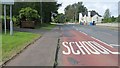
The word on the street
Bann Road (B64) approaches Kilrea.
Image: © Richard Webb
Taken: 30 Jul 2013
0.08 miles