IMAGES TAKEN NEAR TO
Kilrea Road, COLERAINE, BT51 5LR
Introduction
This page details the photographs taken nearby to Kilrea Road, BT51 5LR by members of the Geograph project.
The Geograph project started in 2005 with the aim of publishing, organising and preserving representative images for every square kilometre of Great Britain, Ireland and the Isle of Man.

There are currently over 7.5m images from over14,400 individuals and you can help contribute to the project by visiting https://www.geograph.org.uk
Image Map
Images are licensed for reuse under creativecommons.org/licenses/by-sa/2.0
Notes
- Clicking on the map will re-center to the selected point.
- The higher the marker number, the further away the image location is from the centre of the postcode.
Image Listing (8 Images Found)
Images are licensed for reuse under creativecommons.org/licenses/by-sa/2.0
Image
Details
Distance
1
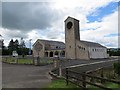
First Garvagh Presbyterian Church
Edenbane Road, Garvagh.
Image: © Richard Webb
Taken: 30 Jul 2013
0.05 miles
2
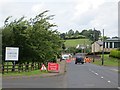
Roadworks, Edenbane Road
The B64 on the edge of Garvagh.
Image: © Richard Webb
Taken: 30 Jul 2013
0.12 miles
3
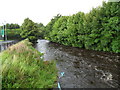
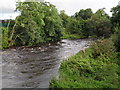
Agivey River, Garvagh
After heavy rainfall - looking north.
Image: © Dean Molyneaux
Taken: 23 Aug 2009
0.21 miles
4
Bridge Street, Garvagh
Leading out over the Agivey River towards Kilrea.
Image: © Dean Molyneaux
Taken: 23 Aug 2009
0.24 miles
5
Agivey River, Garvagh
Looking south from the Killyvally Bridge.
Image: © Dean Molyneaux
Taken: 23 Aug 2009
0.25 miles
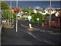
6
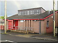
Garvagh Library
It is located at Bridge Street.
Image: © Dean Molyneaux
Taken: 23 Aug 2009
0.25 miles
7
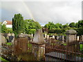
Graveyard, Garvagh
Off Bridge Street.
Image: © Dean Molyneaux
Taken: 23 Aug 2009
0.25 miles
8
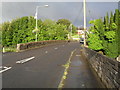
Killyvally Bridge, Garvagh
Over the Agivey River.
Image: © Dean Molyneaux
Taken: 23 Aug 2009
0.25 miles