IMAGES TAKEN NEAR TO
Temple Road, COLERAINE, BT51 5BJ
Introduction
This page details the photographs taken nearby to Temple Road, BT51 5BJ by members of the Geograph project.
The Geograph project started in 2005 with the aim of publishing, organising and preserving representative images for every square kilometre of Great Britain, Ireland and the Isle of Man.

There are currently over 7.5m images from over14,400 individuals and you can help contribute to the project by visiting https://www.geograph.org.uk
Image Map
Images are licensed for reuse under creativecommons.org/licenses/by-sa/2.0
Notes
- Clicking on the map will re-center to the selected point.
- The higher the marker number, the further away the image location is from the centre of the postcode.
Image Listing (5 Images Found)
Images are licensed for reuse under creativecommons.org/licenses/by-sa/2.0
Image
Details
Distance
1
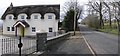
House at Churchtown Road, Brockagh
A fine example of a thatched roof.
Image: © Kenneth Allen
Taken: 27 Mar 2008
0.05 miles
2
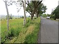
Churchtown Road
Heading west towards Dungiven
Image: © Kenneth Allen
Taken: 26 Mar 2008
0.09 miles
3
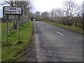
Temple Road
A long straight section with a sign confirming that it is only 9 miles (14km) to Dungiven.
Image: © Richard Webb
Taken: 30 Jul 2013
0.15 miles
4
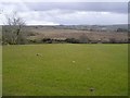
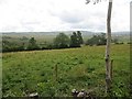
Brockagh Townland
Looking south from the Churchtown Road towards Brockaghboy.
Image: © Kenneth Allen
Taken: 26 Mar 2008
0.18 miles