IMAGES TAKEN NEAR TO
Churchtown Road, COLERAINE, BT51 5BE
Introduction
This page details the photographs taken nearby to Churchtown Road, BT51 5BE by members of the Geograph project.
The Geograph project started in 2005 with the aim of publishing, organising and preserving representative images for every square kilometre of Great Britain, Ireland and the Isle of Man.

There are currently over 7.5m images from over14,400 individuals and you can help contribute to the project by visiting https://www.geograph.org.uk
Image Map
Images are licensed for reuse under creativecommons.org/licenses/by-sa/2.0
Notes
- Clicking on the map will re-center to the selected point.
- The higher the marker number, the further away the image location is from the centre of the postcode.
Image Listing (6 Images Found)
Images are licensed for reuse under creativecommons.org/licenses/by-sa/2.0
Image
Details
Distance
1
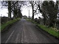
Ballyrogan Road
Heading south-east towards Churchtown
Image: © Kenneth Allen
Taken: 26 Mar 2008
0.10 miles
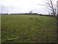
2
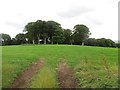
Field near Ballintemple Church
The Agivey River flows behind the wooded hill.
Image: © Richard Webb
Taken: 30 Jul 2013
0.11 miles
3
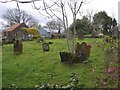
Errigal old church and souterrain
A very old site. The church is believed to date from the 7th Century.
Image: © Kenneth Allen
Taken: 26 Mar 2008
0.12 miles
4
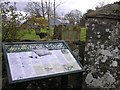
Glenmullin Errigle Old Church site, Plaque
It is located on the Churchtown Road.
Image: © Kenneth Allen
Taken: 26 Mar 2008
0.12 miles
5
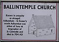
Plaque, Ballintemple Church
It explains some of the history of the church
Image: © Kenneth Allen
Taken: 26 Mar 2008
0.12 miles
6
Churchtown Townland
Looking east from the Ballyrogan Road
Image: © Kenneth Allen
Taken: 26 Mar 2008
0.13 miles