IMAGES TAKEN NEAR TO
Exorna Park, COLERAINE, BT51 4UX
Introduction
This page details the photographs taken nearby to Exorna Park, BT51 4UX by members of the Geograph project.
The Geograph project started in 2005 with the aim of publishing, organising and preserving representative images for every square kilometre of Great Britain, Ireland and the Isle of Man.

There are currently over 7.5m images from over14,400 individuals and you can help contribute to the project by visiting https://www.geograph.org.uk
Image Map
Images are licensed for reuse under creativecommons.org/licenses/by-sa/2.0
Notes
- Clicking on the map will re-center to the selected point.
- The higher the marker number, the further away the image location is from the centre of the postcode.
Image Listing (6 Images Found)
Images are licensed for reuse under creativecommons.org/licenses/by-sa/2.0
Image
Details
Distance
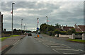
3
Mark Memorial Hall, Articlave
It is located along the Mussenden Road
Image: © Kenneth Allen
Taken: 18 Apr 2010
0.20 miles
4
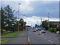
St. Pauls Road
This is St. Pauls Road as it enters the village of Articlave. The name of the village is derived from the 'Irish "Ard an Chléibh", meaning 'height of the basket'. The spelling of the name has changed several times over the preceding years, which I suppose is not that unusual.
Image: © Malcolm Neal
Taken: 27 Jul 2022
0.21 miles
5
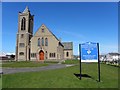
First Dunboe Presbyterian Church
It is located along the Mussenden Road.
Image: © Kenneth Allen
Taken: 18 Apr 2010
0.23 miles
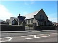
6
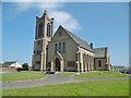
Articlave, church
First Dunboe Presbyterian Church, on St. Paul's Road: http://www.1st-dunboe.co.uk/
Image: © Mike Faherty
Taken: 30 Jun 2018
0.24 miles