IMAGES TAKEN NEAR TO
Altikeeragh Road, COLERAINE, BT51 4SR
Introduction
This page details the photographs taken nearby to Altikeeragh Road, BT51 4SR by members of the Geograph project.
The Geograph project started in 2005 with the aim of publishing, organising and preserving representative images for every square kilometre of Great Britain, Ireland and the Isle of Man.

There are currently over 7.5m images from over14,400 individuals and you can help contribute to the project by visiting https://www.geograph.org.uk
Image Map
Images are licensed for reuse under creativecommons.org/licenses/by-sa/2.0
Notes
- Clicking on the map will re-center to the selected point.
- The higher the marker number, the further away the image location is from the centre of the postcode.
Image Listing (7 Images Found)
Images are licensed for reuse under creativecommons.org/licenses/by-sa/2.0
Image
Details
Distance
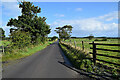
1
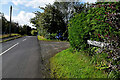
Altikeeragh Road, Ballyhacket Toberclaw / Ballyhacket Lisawilling
Heading south from the junction with Artidillon Road
Image: © Kenneth Allen
Taken: 24 Aug 2024
0.07 miles
2
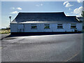
Ballyhackett Primary School, Ballyhacket Toberclaw
Note: spelt differently to the townland.
There is a "For Sale" sign beside it.
Image: © Kenneth Allen
Taken: 24 Aug 2024
0.08 miles
3
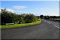
Artidillon Road, Ballyhacket Toberclaw
Heading north-west from Altikeeragh Road
Image: © Kenneth Allen
Taken: 24 Aug 2024
0.08 miles
4
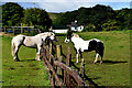
Communicating across the fence, Ballyhacket Lisawilling
These two horses were spotted along Altikeeragh Road
Image: © Kenneth Allen
Taken: 24 Aug 2024
0.14 miles
5
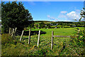
Ballyhacket Lisawilling Townland
Pictured along Altikeeragh Road
Image: © Kenneth Allen
Taken: 24 Aug 2024
0.18 miles
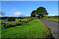
6
Altikeeragh Road, Ballyhacket Toberclaw
Heading north
Image: © Kenneth Allen
Taken: 24 Aug 2024
0.19 miles
7
Ballyhacket Lane, Ballyhacket Lisawilling
Heading WSW from Altikeeragh Road
Image: © Kenneth Allen
Taken: 24 Aug 2024
0.23 miles