IMAGES TAKEN NEAR TO
Seacoast Road, COLERAINE, BT51 4SD
Introduction
This page details the photographs taken nearby to Seacoast Road, BT51 4SD by members of the Geograph project.
The Geograph project started in 2005 with the aim of publishing, organising and preserving representative images for every square kilometre of Great Britain, Ireland and the Isle of Man.

There are currently over 7.5m images from over14,400 individuals and you can help contribute to the project by visiting https://www.geograph.org.uk
Image Map
Images are licensed for reuse under creativecommons.org/licenses/by-sa/2.0
Notes
- Clicking on the map will re-center to the selected point.
- The higher the marker number, the further away the image location is from the centre of the postcode.
Image Listing (11 Images Found)
Images are licensed for reuse under creativecommons.org/licenses/by-sa/2.0
Image
Details
Distance
1
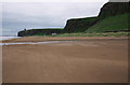
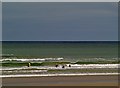
Downhill Strand
The beach at Downhill Strand between Mussenden Temple and Benone.
Image: © Rossographer
Taken: 30 Jun 2012
0.06 miles
2
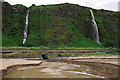
Waterfalls, Downhill
Waterfalls on cliffs above the coast road and railway at Downhill. The waterfalls, swollen by recent heavy rain, merge into one river and are diverted under both road and track to enter the beach through the tunnel.
Image: © Rossographer
Taken: 30 Jun 2012
0.08 miles
3
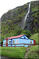
Running Water
One of a number of waterfalls between Downhill and Benone on the Seacoast Road (A2) Co.Londonderry.http://www.panoramio.com/user/574636
Image: © Shane Killen
Taken: 10 Jul 2007
0.09 miles
4
A2, Benone
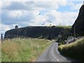
Giant kites are flying above Downhill Desmene. Heading east, Downhill is a misnomer, the road climbs up to the plateau, leaving the narrow coastal strip.
Image: © Richard Webb
Taken: 4 Aug 2013
0.10 miles
5
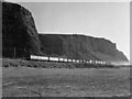
Freight train at Downhill - 1977
Two UTA built 70-class DEMUs haul the nightly (Monday - Friday) Londonderry (Waterside) - Lisburn freight service past the strand at Downhill. See: Image]
Image: © The Carlisle Kid
Taken: 21 Jun 1977
0.14 miles
6
Castelrock strand
Enjoying the surf at Castlerock.
Image: © Robert Ashby
Taken: 15 Sep 2008
0.14 miles
7
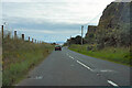
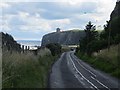
Seacoast Road
Though it is not visible, there is a railway line to the left of the barbed wire fence on the left of the image and beyond that is a sandy beach. The sea is just visible in the distance beyond the cars on the road.
Image: © Malcolm Neal
Taken: 27 Jul 2022
0.15 miles
8
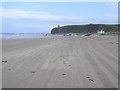
Downhill Strand, Derry / Londonderry
Looking south-east
Image: © Kenneth Allen
Taken: 19 Aug 2006
0.17 miles
9
A2 approaching Downhill
Several very large kites are being flown, which explains why there is a whale in the sky.
Image: © Richard Webb
Taken: 4 Aug 2013
0.20 miles
10
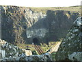
Downhill Railway Tunnel
Downhill Tunnel taken from cliffs above. This tunnel was closed from time to time due to falling rock. This picture shows clearly the work that was carried out by N.I.R. to prevent any further slippage or landslides.
Image: © David Laverty
Taken: 14 Feb 2008
0.24 miles