IMAGES TAKEN NEAR TO
Promenade, COLERAINE, BT51 4RF
Introduction
This page details the photographs taken nearby to Promenade, BT51 4RF by members of the Geograph project.
The Geograph project started in 2005 with the aim of publishing, organising and preserving representative images for every square kilometre of Great Britain, Ireland and the Isle of Man.

There are currently over 7.5m images from over14,400 individuals and you can help contribute to the project by visiting https://www.geograph.org.uk
Image Map
Images are licensed for reuse under creativecommons.org/licenses/by-sa/2.0
Notes
- Clicking on the map will re-center to the selected point.
- The higher the marker number, the further away the image location is from the centre of the postcode.
Image Listing (89 Images Found)
Images are licensed for reuse under creativecommons.org/licenses/by-sa/2.0
Image
Details
Distance
1
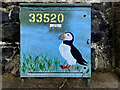
Utility cabinet, Castlerock
I noticed similar decorated cabinets in Coleraine
Pictured here Image]
Image: © Kenneth Allen
Taken: 24 Aug 2024
0.01 miles
2
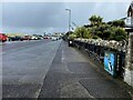
Promenade, Castlerock
Heading ESE from Freehall Dunlop to Freehall Watson
My attention was drawn to Image]
Image: © Kenneth Allen
Taken: 24 Aug 2024
0.01 miles
3
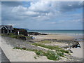
Castlerock beach
The west end of Castlerock beach. In the far distance is Inishowen Head in Donegal.
Image: © Kay Atherton
Taken: 29 Jul 2008
0.02 miles
4

The Promenade, Castlerock
More of a road by the sea than a conventional promenade. The beach Image is on the left behind the dunes.
Image: © Albert Bridge
Taken: 18 Mar 2008
0.05 miles
5
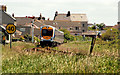
Train, Castlerock
The 11.10 Belfast Gt Victoria Street – Londonderry has just departed Castlerock station (background) and is approaching the level crossing Image before the tunnel Image There are two, of the few remaining, somersault signals visible to the left and right of the train.
Image: © Albert Bridge
Taken: 12 Jun 2010
0.07 miles
6
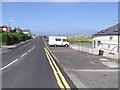
The Promenade, Castlerock
Looking WNW
Image: © Kenneth Allen
Taken: 29 May 2009
0.07 miles
7
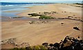
The shore at Castlerock (1)
Castlerock beach has almost ¾ mile of firm sand along the shore of the north Atlantic. Not very busy today. The view is east with the Barmouth Image at upper middle.
Image: © Albert Bridge
Taken: 18 Mar 2008
0.09 miles
8
"Whistle" sign, Castlerock station
A “Whistle” board, for down trains, departing Castlerock and approaching the accommodation crossing Image before the tunnel Image Trains now have horns but the term “whistle” remains from the age of steam.
Image: © Albert Bridge
Taken: 2 Sep 2012
0.09 miles
10
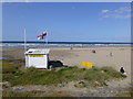
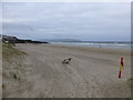
Lifeguard station, Castlerock
Looking northwards at the beach
Image: © Kenneth Allen
Taken: 4 Aug 2014
0.09 miles